IMAGES TAKEN NEAR TO
Normans Way, ILFRACOMBE, EX34 9JN
Introduction
This page details the photographs taken nearby to Normans Way, EX34 9JN by members of the Geograph project.
The Geograph project started in 2005 with the aim of publishing, organising and preserving representative images for every square kilometre of Great Britain, Ireland and the Isle of Man.

There are currently over 7.5m images from over14,400 individuals and you can help contribute to the project by visiting https://www.geograph.org.uk
Image Map
Images are licensed for reuse under creativecommons.org/licenses/by-sa/2.0
Notes
- Clicking on the map will re-center to the selected point.
- The higher the marker number, the further away the image location is from the centre of the postcode.
Image Listing (283 Images Found)
Images are licensed for reuse under creativecommons.org/licenses/by-sa/2.0
Image
Details
Distance

2
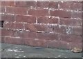
Ordnance Survey Cut Mark
This OS cut mark can be found on the west face of No68 Whittingham Road. It marks a point 93.120m above mean sea level.
Image: © Adrian Dust
Taken: 16 Feb 2017
0.06 miles
3

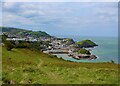
Ilfracombe Town
Overlooking the town from Capstone Point
Image: © trevor peach
Taken: 10 Jul 2007
0.06 miles
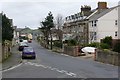
4
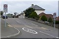
Whittingham Road at the junction with Worth Road
Image: © Roger A Smith
Taken: 20 Mar 2008
0.06 miles
6
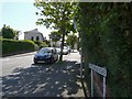
Whitingham road as it leaves Highfield road
Image: © Roger A Smith
Taken: 19 May 2008
0.08 miles
7
View towards Ilfracombe from Hillsborough Hillfort
Image: © Lauren
Taken: 5 May 2017
0.08 miles
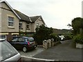
8
Highfield Road with the Torrs in the background
Image: © Roger A Smith
Taken: 20 Mar 2008
0.08 miles

10
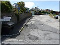
Castle Hill Avenue at the junction with Castle Hill.
Image: © Roger A Smith
Taken: 30 Jun 2008
0.08 miles