IMAGES TAKEN NEAR TO
West Down, ILFRACOMBE, EX34 8NG
Introduction
This page details the photographs taken nearby to EX34 8NG by members of the Geograph project.
The Geograph project started in 2005 with the aim of publishing, organising and preserving representative images for every square kilometre of Great Britain, Ireland and the Isle of Man.

There are currently over 7.5m images from over14,400 individuals and you can help contribute to the project by visiting https://www.geograph.org.uk
Image Map
Images are licensed for reuse under creativecommons.org/licenses/by-sa/2.0
Notes
- Clicking on the map will re-center to the selected point.
- The higher the marker number, the further away the image location is from the centre of the postcode.
Image Listing (112 Images Found)
Images are licensed for reuse under creativecommons.org/licenses/by-sa/2.0
Image
Details
Distance
1
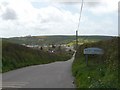
The Ilfracombe Road approaching West Down
See also: Image
Image: © Roger A Smith
Taken: 23 Apr 2008
0.01 miles
2

The Ilfracombe Road leading to West Down
See also: Image
Image: © Roger A Smith
Taken: 8 Jan 2010
0.02 miles
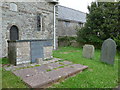
4
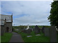
St Calixtus, West Down: churchyard (viii)
Image: © Basher Eyre
Taken: 25 May 2015
0.05 miles
5
St Calixtus, West Down: churchyard (ix)
Image: © Basher Eyre
Taken: 25 May 2015
0.05 miles

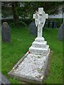
7
St Calixtus, West Down: churchyard (xi)
Image: © Basher Eyre
Taken: 25 May 2015
0.05 miles
8
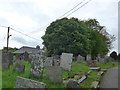
St Calixtus, West Down: churchyard (xii)
Image: © Basher Eyre
Taken: 25 May 2015
0.05 miles
9
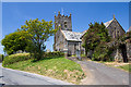
Church of St Calixtus, West Down
A cruciform church dating from the C13, repaired in 1675, and restored in 1841.
Image: © Mike Searle
Taken: 6 Jun 2013
0.06 miles
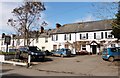
10

West Down : Road
A road through the village.
Image: © Lewis Clarke
Taken: 16 Jan 2021
0.06 miles