IMAGES TAKEN NEAR TO
ILFRACOMBE, EX34 8ND
Introduction
This page details the photographs taken nearby to EX34 8ND by members of the Geograph project.
The Geograph project started in 2005 with the aim of publishing, organising and preserving representative images for every square kilometre of Great Britain, Ireland and the Isle of Man.

There are currently over 7.5m images from over14,400 individuals and you can help contribute to the project by visiting https://www.geograph.org.uk
Image Map
Images are licensed for reuse under creativecommons.org/licenses/by-sa/2.0
Notes
- Clicking on the map will re-center to the selected point.
- The higher the marker number, the further away the image location is from the centre of the postcode.
Image Listing (8 Images Found)
Images are licensed for reuse under creativecommons.org/licenses/by-sa/2.0
Image
Details
Distance
1
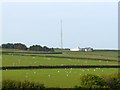
Another view of the Aerial music studio near Hore Down.
Image: © Roger A Smith
Taken: 21 May 2008
0.00 miles
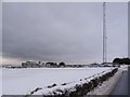
4

A common snipe in the snow on the road side
Image: © Roger A Smith
Taken: 6 Jan 2010
0.08 miles
5
West Down : A3123
Looking along the road.
Image: © Lewis Clarke
Taken: 16 Jan 2021
0.18 miles
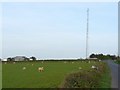
6
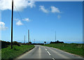
Heading west along the A3123
Near the junction of the A3123 and a minor road leading to West Down. In the background is an aerial mast to the right of the main road. The Atlantic Ocean can be seen on the horizon.
Image: © Peter Kazmierczak
Taken: 11 Apr 2012
0.20 miles
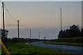
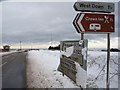
7
The road leading from the A3123 to West Down
Image: © Roger A Smith
Taken: 6 Jan 2010
0.21 miles
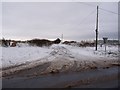
8
The A3123 at the junction with the road to West Down
Image: © Roger A Smith
Taken: 6 Jan 2010
0.21 miles