IMAGES TAKEN NEAR TO
Torrs Park, ILFRACOMBE, EX34 8FW
Introduction
This page details the photographs taken nearby to Torrs Park, EX34 8FW by members of the Geograph project.
The Geograph project started in 2005 with the aim of publishing, organising and preserving representative images for every square kilometre of Great Britain, Ireland and the Isle of Man.

There are currently over 7.5m images from over14,400 individuals and you can help contribute to the project by visiting https://www.geograph.org.uk
Image Map (Loading...)


Getting Data...Please wait
Leaflet Map data © OpenStreetMap
Images are licensed for reuse under creativecommons.org/licenses/by-sa/2.0
Notes
- Clicking on the map will re-center to the selected point.
- The higher the marker number, the further away the image location is from the centre of the postcode.
Image Listing (929 Images Found)
Images are licensed for reuse under creativecommons.org/licenses/by-sa/2.0
Image
Details
Distance
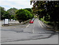
2

Brookdale Avenue at the junction with Osborne Road.
Image: © Roger A Smith
Taken: 10 May 2008
0.02 miles
3
Riversdale Avenue, Ilfracombe
From the corner of Church Road & Brookdale Avenue along Riversdale Avenue towards Torrs Park.
A coach park http://www.geograph.org.uk/photo/5441347 is on the left.
Image: © Jaggery
Taken: 25 Jun 2017
0.02 miles
4

The Co-op supermarket on Wilder Road.
The supermarket is clearly visible as is the graveyard of the parish church in the foreground
Image: © Roger A Smith
Taken: 28 Mar 2009
0.02 miles
5
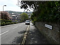
Riversdale Avenue between Torrs Park & Brookdale Avenue
Image: © Roger A Smith
Taken: 10 May 2008
0.03 miles
6

To Let, Wilder Road, Ilfracombe.
This property was built as part of the Co-op development and was previously Maylings Garage.
Image: © Roger A Smith
Taken: 26 Jan 2009
0.03 miles
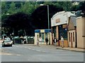
7

Lidl Supermarket, Wilder road, Ilfracombe
Image: © Roger A Smith
Taken: 1 Mar 2010
0.03 miles
8
Maylings Garage, Wilder Road, Ilfracombe.
This Property is now the Co-op Supermarket. Maylings has moved to an Industrial Estate. Image
Image: © Roger A Smith
Taken: Unknown
0.03 miles
9

Co-op supermarket, Wilder Road, Ilfracombe.
This store has moved here: Image
Image: © Roger A Smith
Taken: 26 Jan 2009
0.03 miles
10

Wilder Road between Northfield Road and Greenclose Road
See also: Image
Image: © Roger A Smith
Taken: 23 Oct 2009
0.03 miles