IMAGES TAKEN NEAR TO
Arbour Close, ILFRACOMBE, EX34 8EY
Introduction
This page details the photographs taken nearby to Arbour Close, EX34 8EY by members of the Geograph project.
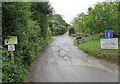
The Geograph project started in 2005 with the aim of publishing, organising and preserving representative images for every square kilometre of Great Britain, Ireland and the Isle of Man.

There are currently over 7.5m images from over14,400 individuals and you can help contribute to the project by visiting https://www.geograph.org.uk
Image Map (Loading...)


Getting Data...Please wait
Leaflet Map data © OpenStreetMap
Images are licensed for reuse under creativecommons.org/licenses/by-sa/2.0
Notes
- Clicking on the map will re-center to the selected point.
- The higher the marker number, the further away the image location is from the centre of the postcode.
Image Listing (96 Images Found)
Images are licensed for reuse under creativecommons.org/licenses/by-sa/2.0
Image
Details
Distance
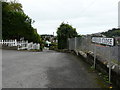
2

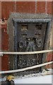
Ordnance Survey Rivet
This OS rivet can be found on the top step of the path. It marks a point 81.348m above mean sea level.
Image: © Adrian Dust
Taken: 16 Feb 2017
0.04 miles
3
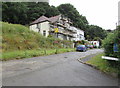
Kingsley Avenue house under scaffolding, Ilfracombe
Viewed from the corner of Arbour Close in June 2017.
Image: © Jaggery
Taken: 25 Jun 2017
0.04 miles
4
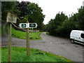
Cairn Road where it leads away from Kingsley Avenue.
Image: © Roger A Smith
Taken: 29 Aug 2008
0.05 miles
5

Bicclescombe Park Road at the junction with Bicclescombe Gardens.
Image: © Roger A Smith
Taken: 29 Aug 2008
0.06 miles
6
Kingsley Avenue approaching the point where it merges with Cairn Road.
Image: © Roger A Smith
Taken: 29 Aug 2008
0.06 miles
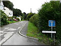
7
Kingsley Avenue, Ilfracombe
Ascending from the A361, this part of Kingsley Avenue leads to Cairnside, Arbour Close and Cairn Road.
Image: © Jaggery
Taken: 25 Jun 2017
0.07 miles
8

Bicclescombe Park Road with Bicclescombe Gardens to the right.
Image: © Roger A Smith
Taken: 29 Aug 2008
0.07 miles
9

Saint Brannock's Road at the junction with Kingsely Avenue
Image: © Roger A Smith
Taken: 29 Aug 2008
0.07 miles
10
Ordnance Survey Flush Bracket (G4850)
This OS Flush Bracket can be found on No40 St Brannocks Road. It marks a point 49.319m above mean sea level.
Image: © Adrian Dust
Taken: 16 Feb 2017
0.08 miles