IMAGES TAKEN NEAR TO
Brookfield Place, ILFRACOMBE, EX34 8BX
Introduction
This page details the photographs taken nearby to Brookfield Place, EX34 8BX by members of the Geograph project.
The Geograph project started in 2005 with the aim of publishing, organising and preserving representative images for every square kilometre of Great Britain, Ireland and the Isle of Man.

There are currently over 7.5m images from over14,400 individuals and you can help contribute to the project by visiting https://www.geograph.org.uk
Image Map
Images are licensed for reuse under creativecommons.org/licenses/by-sa/2.0
Notes
- Clicking on the map will re-center to the selected point.
- The higher the marker number, the further away the image location is from the centre of the postcode.
Image Listing (1072 Images Found)
Images are licensed for reuse under creativecommons.org/licenses/by-sa/2.0
Image
Details
Distance
1
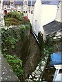
The East Wilder Brook it where briefly emerges from underground
Image: © Roger A Smith
Taken: 27 Nov 2009
0.01 miles
2
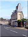
An interesting building on Wilder Road
This building, now used as a youth accommodation, centre was part of the gasworks that used to be on the Wilder Road car park which is just behind it.
Image: © Roger A Smith
Taken: 10 May 2008
0.02 miles
3
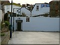
The rear entrance to the Wellington Arms in the Wilder Road car park
See: Image
Image: © Roger A Smith
Taken: 7 Nov 2009
0.02 miles
4
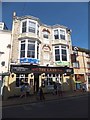
The Lamb Inn, Ilfracombe High Street
The facade has the date 1893, above the name "Lamb Hotel". It retains period stained glass at the top of the first floor bay windows. This building has reverted to its original role; Image and Image show the ground floor in 2009 when it was a bar and a restaurant
Image: © David Smith
Taken: 20 Aug 2013
0.03 miles
5
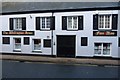
The Wellington Arms, No. 66 The High Street, Ilfracombe.
Image: © Roger A Smith
Taken: 17 Jan 2009
0.03 miles
6
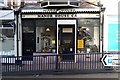
Manor House Cafe, No. 70 The High Street, Ilfracombe.
The last Shop on this side of the High Street. From this point it becomes Church Street.
Image: © Roger A Smith
Taken: 17 Jan 2009
0.03 miles
7
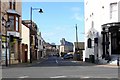
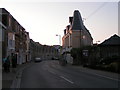
Wilder Road at the junction with Church Street
The white building on the right of the junction used to be an hotel before WW2.
Image: © Roger A Smith
Taken: 26 Mar 2008
0.03 miles
8
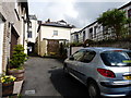
Friendship Lane as seen from Jubilee Close looking towards the High Street
Image: © Roger A Smith
Taken: 30 Apr 2009
0.03 miles
9
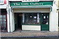
The Gift Gallery, No. 64 The High Street, Ilfracombe.
Image: © Roger A Smith
Taken: 17 Jan 2009
0.03 miles