IMAGES TAKEN NEAR TO
Poole Lane, WOOLACOMBE, EX34 7AP
Introduction
This page details the photographs taken nearby to Poole Lane, EX34 7AP by members of the Geograph project.
The Geograph project started in 2005 with the aim of publishing, organising and preserving representative images for every square kilometre of Great Britain, Ireland and the Isle of Man.

There are currently over 7.5m images from over14,400 individuals and you can help contribute to the project by visiting https://www.geograph.org.uk
Image Map
Images are licensed for reuse under creativecommons.org/licenses/by-sa/2.0
Notes
- Clicking on the map will re-center to the selected point.
- The higher the marker number, the further away the image location is from the centre of the postcode.
Image Listing (33 Images Found)
Images are licensed for reuse under creativecommons.org/licenses/by-sa/2.0
Image
Details
Distance
2
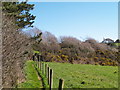
Path heading to Poole Lane
From the Woolacombe Bay Holiday Park the path heading to Poole Lane
Image: © Shaun Ferguson
Taken: 21 Sep 2020
0.14 miles
3
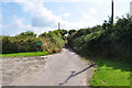
Poole Lane leading from Mortehoe Station Road to Poole Farm
Image: © Roger A Smith
Taken: 2 Jul 2010
0.15 miles
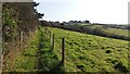
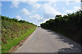
5
Sandy Lane approaching Mortehoe Station Road
Image: © Roger A Smith
Taken: 23 Jul 2010
0.15 miles
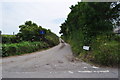
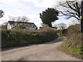
6
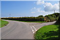
A road junction on Sandy Lane
Sandy Lane continues to the right.
Image: © Roger A Smith
Taken: 23 Jul 2010
0.15 miles
9
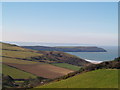
Coastal View
The view from a footpath on the side of a Coombe looking towards Morte Bay, with Baggy Point jutting out into the Bristol Channel.
Image: © Chris McAuley
Taken: 21 Mar 2015
0.17 miles