IMAGES TAKEN NEAR TO
Wet Lane, ILFRACOMBE, EX34 0LS
Introduction
This page details the photographs taken nearby to Wet Lane, EX34 0LS by members of the Geograph project.
The Geograph project started in 2005 with the aim of publishing, organising and preserving representative images for every square kilometre of Great Britain, Ireland and the Isle of Man.

There are currently over 7.5m images from over14,400 individuals and you can help contribute to the project by visiting https://www.geograph.org.uk
Image Map
Images are licensed for reuse under creativecommons.org/licenses/by-sa/2.0
Notes
- Clicking on the map will re-center to the selected point.
- The higher the marker number, the further away the image location is from the centre of the postcode.
Image Listing (155 Images Found)
Images are licensed for reuse under creativecommons.org/licenses/by-sa/2.0
Image
Details
Distance
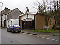
2

Combe Martin : Castle Street A399
Looking along Castle Street and its pavement.
Image: © Lewis Clarke
Taken: 8 Jun 2023
0.02 miles
3
Combe Martin : Castle Street A399
Looking along Castle Street.
Image: © Lewis Clarke
Taken: 8 Jun 2023
0.02 miles
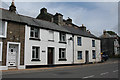
4
Combe Martin Methodist Church
High Street, Combe Martin.
Image: © Anthony Vosper
Taken: 23 Jul 2011
0.02 miles
5
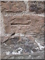
Ordnance Survey Cut Mark
This OS cut mark can be found on the SE face of the Methodist Chapel. It marks a point 31.504m above mean sea level.
Image: © Adrian Dust
Taken: 17 Oct 2015
0.02 miles
6
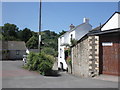
Combe Martin : Sunnyside
Looking along Sunnyside off Castle Street.
Image: © Lewis Clarke
Taken: 8 Jun 2023
0.02 miles
7
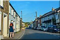
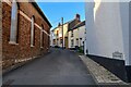
Combe Martin: Miners Cottages
In Castle Street. Combe Martin is a notably linear village in the Umber valley and Castle Street, later High Street, forms the main road to Ilfracombe. The village clusters along it for a distance of two miles. Mining was one of the village’s past industries, together with hemp growing and lime burning. But the village majored on agriculture and strawberries were grown on the valley sides
Image: © Martin Bodman
Taken: 16 Jul 2008
0.03 miles
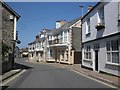
8
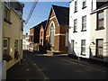
Combe Martin: Castle Street
The village is largely built along this street, which becomes High Street nearer the coast, and is essentially linear, spread along the Umber valley for a distance of about two miles. Looking towards the Methodist chapel, right
Image: © Martin Bodman
Taken: 16 Jul 2008
0.03 miles
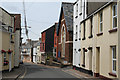
10
Catholic Church, High Street
At this moment in time it appears to be closed down.
Image: © Anthony Vosper
Taken: 21 Jan 2012
0.07 miles