IMAGES TAKEN NEAR TO
Knowle, BRAUNTON, EX33 2LW
Introduction
This page details the photographs taken nearby to EX33 2LW by members of the Geograph project.
The Geograph project started in 2005 with the aim of publishing, organising and preserving representative images for every square kilometre of Great Britain, Ireland and the Isle of Man.

There are currently over 7.5m images from over14,400 individuals and you can help contribute to the project by visiting https://www.geograph.org.uk
Image Map
Images are licensed for reuse under creativecommons.org/licenses/by-sa/2.0
Notes
- Clicking on the map will re-center to the selected point.
- The higher the marker number, the further away the image location is from the centre of the postcode.
Image Listing (34 Images Found)
Images are licensed for reuse under creativecommons.org/licenses/by-sa/2.0
Image
Details
Distance
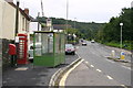
2
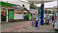
Knowle : Knowle Garage Londis
Storm Eunice has blown the sign above the shop off.
Image: © Lewis Clarke
Taken: 18 Feb 2022
0.02 miles
3

Knowle : Knowle Garage Londis
Storm Eunice has blown the sign above the shop off.
Image: © Lewis Clarke
Taken: 18 Feb 2022
0.02 miles
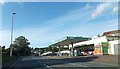
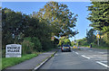
4
A361 through Knowle on the way to Braunton
A361 through Knowle on the way to Braunton
Image: © Shaun Ferguson
Taken: 2 Aug 2007
0.02 miles
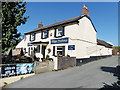
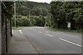
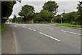
7
The Winsham Road and Ebrington Alms in Knowle
See: http://www.myspace.com/155776769
Image: © Roger A Smith
Taken: 8 Jan 2010
0.05 miles
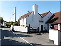
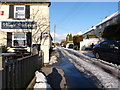
8
The junction of the A361 with Winsham Road at Knowle
Image: © Roger A Smith
Taken: 11 Sep 2010
0.08 miles