IMAGES TAKEN NEAR TO
Chaloners Road, BRAUNTON, EX33 2JA
Introduction
This page details the photographs taken nearby to Chaloners Road, EX33 2JA by members of the Geograph project.
The Geograph project started in 2005 with the aim of publishing, organising and preserving representative images for every square kilometre of Great Britain, Ireland and the Isle of Man.

There are currently over 7.5m images from over14,400 individuals and you can help contribute to the project by visiting https://www.geograph.org.uk
Image Map
Images are licensed for reuse under creativecommons.org/licenses/by-sa/2.0
Notes
- Clicking on the map will re-center to the selected point.
- The higher the marker number, the further away the image location is from the centre of the postcode.
Image Listing (172 Images Found)
Images are licensed for reuse under creativecommons.org/licenses/by-sa/2.0
Image
Details
Distance
2
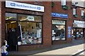
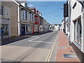
The RSPCA charity shop, Chaloner's Road, Braunton
Image: © Roger A Smith
Taken: 7 Jan 2009
0.02 miles
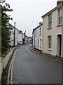
3
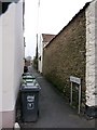
Bias Lane viewed from East Street
See also: Image
Image: © Roger A Smith
Taken: 14 Jan 2010
0.03 miles
4
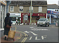
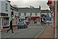
Basket case, Braunton
A shopper walks along Caen Street dragging her trolley - those things should be licensed.
Image: © Pauline E
Taken: 22 May 2009
0.03 miles
5
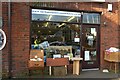
The North Devon Animal Ambulance Charity Shop, Chaloner's Road, Braunton
Image: © Roger A Smith
Taken: 7 Jan 2009
0.03 miles
6

North Devon Hospice Charity Shop, Caen Street, Braunton
Image: © Roger A Smith
Taken: 18 Jul 2013
0.04 miles
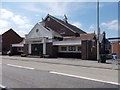
7
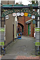
Cross Tree Centre on Caen Street, Braunton
Image: © Roger A Smith
Taken: 13 Feb 2016
0.04 miles