IMAGES TAKEN NEAR TO
Butts Path, BRAUNTON, EX33 2EU
Introduction
This page details the photographs taken nearby to Butts Path, EX33 2EU by members of the Geograph project.
The Geograph project started in 2005 with the aim of publishing, organising and preserving representative images for every square kilometre of Great Britain, Ireland and the Isle of Man.

There are currently over 7.5m images from over14,400 individuals and you can help contribute to the project by visiting https://www.geograph.org.uk
Image Map
Images are licensed for reuse under creativecommons.org/licenses/by-sa/2.0
Notes
- Clicking on the map will re-center to the selected point.
- The higher the marker number, the further away the image location is from the centre of the postcode.
Image Listing (254 Images Found)
Images are licensed for reuse under creativecommons.org/licenses/by-sa/2.0
Image
Details
Distance
1
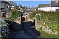
A footbridge over the river Caen leading from the cemetery to Ropers Walk
Image: © Roger A Smith
Taken: 6 Dec 2010
0.02 miles
2
A footbridge over the river Caen leading from the Cemetery to Ropers Walk
Image: © Roger A Smith
Taken: 6 Dec 2010
0.02 miles
3

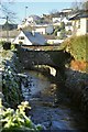
Footbridge over River Caen
The footbridge over the river leads into the churchyard of St. Brannock's.
Image: © David P Howard
Taken: 6 Jul 2012
0.02 miles
4
The view downstream from Dean's bridge on the river Caen
Image: © Roger A Smith
Taken: 6 Dec 2010
0.02 miles
6
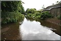
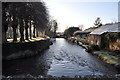
River Caen
Looking south towards the village along the River Caen near St.Brannock's church
Image: © Richard Croft
Taken: 2 Jul 2008
0.03 miles
7

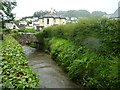
The view upstream on the river Caen from Butts Bridge
Image: © Roger A Smith
Taken: 6 Dec 2010
0.04 miles
8

Butts Bridge on the river Caen as seen from upstream
Image: © Roger A Smith
Taken: 6 Dec 2010
0.04 miles
9
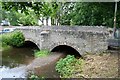
Churchside bridge
Ancient bridge over the River Caen near St.Brannock's church
Image: © Richard Croft
Taken: 2 Jul 2008
0.04 miles
