IMAGES TAKEN NEAR TO
Wrafton, BRAUNTON, EX33 2DN
Introduction
This page details the photographs taken nearby to EX33 2DN by members of the Geograph project.
The Geograph project started in 2005 with the aim of publishing, organising and preserving representative images for every square kilometre of Great Britain, Ireland and the Isle of Man.

There are currently over 7.5m images from over14,400 individuals and you can help contribute to the project by visiting https://www.geograph.org.uk
Image Map (Loading...)


Getting Data...Please wait
Leaflet Map data © OpenStreetMap
Images are licensed for reuse under creativecommons.org/licenses/by-sa/2.0
Notes
- Clicking on the map will re-center to the selected point.
- The higher the marker number, the further away the image location is from the centre of the postcode.
Image Listing (58 Images Found)
Images are licensed for reuse under creativecommons.org/licenses/by-sa/2.0
Image
Details
Distance
1

Wrafton : Braunton Royal British Legion
The Royal British Legion base on Hart Manor.
Image: © Lewis Clarke
Taken: 20 Jun 2020
0.02 miles

3
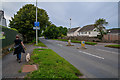
Wrafton : Exeter Road A361
Looking along the A361.
Image: © Lewis Clarke
Taken: 20 Jun 2020
0.03 miles
4

Wrafton : Footpath
A footpath to bungalows on Hart Manor.
Image: © Lewis Clarke
Taken: 20 Jun 2020
0.03 miles
5
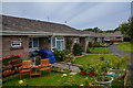
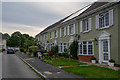
Wrafton : Hart Manor
Looking along Hart Manor.
Image: © Lewis Clarke
Taken: 20 Jun 2020
0.05 miles
6

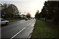
The A361 passing over Heanton bridge on Knowl Water
Image: © Roger A Smith
Taken: 3 Feb 2011
0.06 miles
8
The A361 passing over Heanton Bridge on Knowl Water
Image: © Roger A Smith
Taken: 3 Feb 2011
0.06 miles
9
Wrafton : Williams Close
Williams Close off Wrafton Road.
Image: © Lewis Clarke
Taken: 20 Jun 2020
0.06 miles
10

Heanton bridge on Knowl Water as seen from upstream
Image: © Roger A Smith
Taken: 3 Feb 2011
0.07 miles