IMAGES TAKEN NEAR TO
Pill Gardens, BRAUNTON, EX33 2BE
Introduction
This page details the photographs taken nearby to Pill Gardens, EX33 2BE by members of the Geograph project.
The Geograph project started in 2005 with the aim of publishing, organising and preserving representative images for every square kilometre of Great Britain, Ireland and the Isle of Man.

There are currently over 7.5m images from over14,400 individuals and you can help contribute to the project by visiting https://www.geograph.org.uk
Image Map
Images are licensed for reuse under creativecommons.org/licenses/by-sa/2.0
Notes
- Clicking on the map will re-center to the selected point.
- The higher the marker number, the further away the image location is from the centre of the postcode.
Image Listing (73 Images Found)
Images are licensed for reuse under creativecommons.org/licenses/by-sa/2.0
Image
Details
Distance
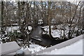
2
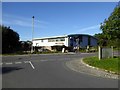
Factory on edge of Braunton
One of the Saltrock company's buildings
Image: © David Smith
Taken: 9 Oct 2015
0.08 miles
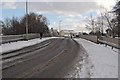
3
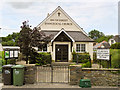
South Street Evangelical Church, Braunton
Image: © Roger A Smith
Taken: 30 Jun 2014
0.09 miles
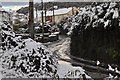
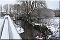
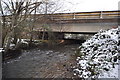
4

A bridge over the river Caen on Vellator Way
Image: © Roger A Smith
Taken: 18 Dec 2010
0.09 miles
5
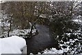
The view upstream on the river Caen from the bridge on Vellator Way
Image: © Roger A Smith
Taken: 18 Dec 2010
0.09 miles
6
The view downstream on the river Caen from the bridge on Vellator Way
Image: © Roger A Smith
Taken: 18 Dec 2010
0.09 miles
7
A bridge over the river Caen on Vellator Way
Image: © Roger A Smith
Taken: 18 Dec 2010
0.09 miles
8
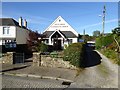
South Street Evangelical Church, Braunton
Image: © David Smith
Taken: 9 Oct 2015
0.09 miles
9
The view downstream from a footbridge on the river Caen, near Tesco Supermarket
Image: © Roger A Smith
Taken: 20 Dec 2010
0.10 miles
10
A bridge over the river Caen on Vellator Way as seen from downstream
Image: © Roger A Smith
Taken: 18 Dec 2010
0.11 miles