IMAGES TAKEN NEAR TO
South Street, BRAUNTON, EX33 2AN
Introduction
This page details the photographs taken nearby to South Street, EX33 2AN by members of the Geograph project.
The Geograph project started in 2005 with the aim of publishing, organising and preserving representative images for every square kilometre of Great Britain, Ireland and the Isle of Man.

There are currently over 7.5m images from over14,400 individuals and you can help contribute to the project by visiting https://www.geograph.org.uk
Image Map
Images are licensed for reuse under creativecommons.org/licenses/by-sa/2.0
Notes
- Clicking on the map will re-center to the selected point.
- The higher the marker number, the further away the image location is from the centre of the postcode.
Image Listing (128 Images Found)
Images are licensed for reuse under creativecommons.org/licenses/by-sa/2.0
Image
Details
Distance

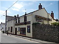
3
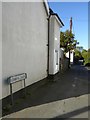
Arlington Terrace, Braunton
This leads to Upright Villas; a curious name
Image: © David Smith
Taken: 9 Oct 2015
0.04 miles
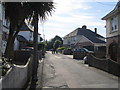
4
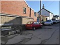
Braunton : Gubbin's Lane
Looking along Gubbin's Lane.
Image: © Lewis Clarke
Taken: 13 Aug 2022
0.05 miles
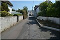
7

Wind turbine blades passing through Braunton on their way to the Fullabrook Down wind farm
Image: © Roger A Smith
Taken: 19 Apr 2011
0.09 miles

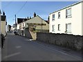
10
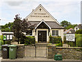
South Street Evangelical Church, Braunton
Image: © Roger A Smith
Taken: 30 Jun 2014
0.09 miles