IMAGES TAKEN NEAR TO
The Village, BRAUNTON, EX33 1LW
Introduction
This page details the photographs taken nearby to The Village, EX33 1LW by members of the Geograph project.
The Geograph project started in 2005 with the aim of publishing, organising and preserving representative images for every square kilometre of Great Britain, Ireland and the Isle of Man.

There are currently over 7.5m images from over14,400 individuals and you can help contribute to the project by visiting https://www.geograph.org.uk
Image Map
Images are licensed for reuse under creativecommons.org/licenses/by-sa/2.0
Notes
- Clicking on the map will re-center to the selected point.
- The higher the marker number, the further away the image location is from the centre of the postcode.
Image Listing (30 Images Found)
Images are licensed for reuse under creativecommons.org/licenses/by-sa/2.0
Image
Details
Distance
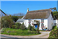
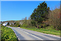
1

Cottages on the B3231 Saunton Road near Warren Farm
Image: © Roger A Smith
Taken: 24 Oct 2010
0.01 miles
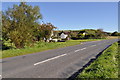
2
Saunton Road
Cottage on Saunton Road.
Image: © Wayland Smith
Taken: 10 Apr 2021
0.01 miles

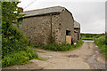
4

Warren Farm on the B3231 Saunton Road
Image: © Roger A Smith
Taken: 28 May 2014
0.03 miles
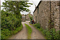
7

Warren Farm on the B3231 Saunton Road
Image: © Roger A Smith
Taken: 28 May 2014
0.04 miles
8
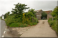
Warren Farm on the B3231 Saunton Road
Image: © Roger A Smith
Taken: 28 May 2014
0.06 miles
10
The B3231 passing cottages near West Saunton Farm
Image: © Roger A Smith
Taken: 24 Oct 2010
0.07 miles