IMAGES TAKEN NEAR TO
Georgeham, BRAUNTON, EX33 1JN
Introduction
This page details the photographs taken nearby to EX33 1JN by members of the Geograph project.
The Geograph project started in 2005 with the aim of publishing, organising and preserving representative images for every square kilometre of Great Britain, Ireland and the Isle of Man.

There are currently over 7.5m images from over14,400 individuals and you can help contribute to the project by visiting https://www.geograph.org.uk
Image Map
Images are licensed for reuse under creativecommons.org/licenses/by-sa/2.0
Notes
- Clicking on the map will re-center to the selected point.
- The higher the marker number, the further away the image location is from the centre of the postcode.
Image Listing (148 Images Found)
Images are licensed for reuse under creativecommons.org/licenses/by-sa/2.0
Image
Details
Distance
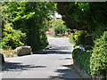
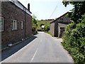
1
Approaching Georgeham from the north on the B3231
Image: © Roger A Smith
Taken: 19 Jun 2010
0.03 miles
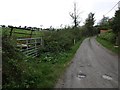
4
Approaching Georgeham on Inclesdon Hill
Image: © Roger A Smith
Taken: 19 Jun 2010
0.05 miles
5
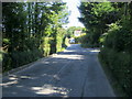
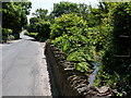
Road heading towards Incledon Hill
Road heading out of Georgeham towards Incledon Hill
Image: © Shaun Ferguson
Taken: 4 Jul 2011
0.05 miles
6
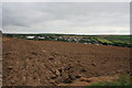
Farmland near Georgeham
The village of Georgeham viewed across a ploughed field.
Image: © Paul E Smith
Taken: 26 Sep 2009
0.08 miles
8
A rather stern looking Burmese cat guarding the steps to Incledon Cottage
Image: © Roger A Smith
Taken: 11 Aug 2010
0.08 miles
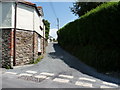
9
Georgeham : Rock Lane
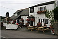
Looking towards the Rock Inn. A sign says they have been shut for a while due to lockdown restrictions.
Image: © Lewis Clarke
Taken: 9 Jan 2021
0.10 miles