IMAGES TAKEN NEAR TO
Scurfield Close, BRAUNTON, EX33 1HQ
Introduction
This page details the photographs taken nearby to Scurfield Close, EX33 1HQ by members of the Geograph project.
The Geograph project started in 2005 with the aim of publishing, organising and preserving representative images for every square kilometre of Great Britain, Ireland and the Isle of Man.

There are currently over 7.5m images from over14,400 individuals and you can help contribute to the project by visiting https://www.geograph.org.uk
Image Map
Images are licensed for reuse under creativecommons.org/licenses/by-sa/2.0
Notes
- Clicking on the map will re-center to the selected point.
- The higher the marker number, the further away the image location is from the centre of the postcode.
Image Listing (254 Images Found)
Images are licensed for reuse under creativecommons.org/licenses/by-sa/2.0
Image
Details
Distance
1
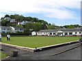
Braunton Bowling Club
The green of the bowling club behind the A361 to Woolacombe. http://www.devon-explorer.co.uk/devon/Braunton/
Image: © Mark Land
Taken: 17 May 2009
0.03 miles

3
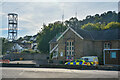
Braunton : Fire Station
Looking across to the fire station on Chaloner's Road.
Image: © Lewis Clarke
Taken: 21 Sep 2021
0.06 miles
4
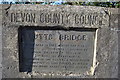
A plaque on Butts Bridge, Chaloner's Road, Braunton
Image: © Roger A Smith
Taken: 6 Dec 2010
0.06 miles
5

Butts Bridge on the river Caen as seen from upstream
Image: © Roger A Smith
Taken: 6 Dec 2010
0.06 miles
6
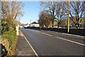
Butts Bridge on the A361, Chaloner's Road
Image: © Roger A Smith
Taken: 6 Dec 2010
0.06 miles
7

Butts bridge on the river Caen as seen from downstream
Image: © Roger A Smith
Taken: 6 Dec 2010
0.06 miles
8
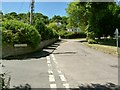
Scurfield Close leading off from the road to Georgeham
Image: © Roger A Smith
Taken: 17 Jun 2010
0.07 miles
9

The view upstream on the river Caen from Butts Bridge
Image: © Roger A Smith
Taken: 6 Dec 2010
0.07 miles
10
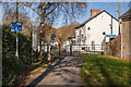
NCN Route 27 split
Cyclists can choose to go left for the normal route or right for the Mountain Bike route.
Image: © Guy Wareham
Taken: 28 Nov 2016
0.07 miles