IMAGES TAKEN NEAR TO
North Street, BRAUNTON, EX33 1FJ
Introduction
This page details the photographs taken nearby to North Street, EX33 1FJ by members of the Geograph project.
The Geograph project started in 2005 with the aim of publishing, organising and preserving representative images for every square kilometre of Great Britain, Ireland and the Isle of Man.

There are currently over 7.5m images from over14,400 individuals and you can help contribute to the project by visiting https://www.geograph.org.uk
Image Map
Images are licensed for reuse under creativecommons.org/licenses/by-sa/2.0
Notes
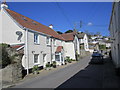
- Clicking on the map will re-center to the selected point.
- The higher the marker number, the further away the image location is from the centre of the postcode.
Image Listing (121 Images Found)
Images are licensed for reuse under creativecommons.org/licenses/by-sa/2.0
Image
Details
Distance
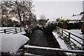
2
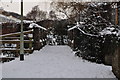
A footbridge over the river Caen near the primary school
Image: © Roger A Smith
Taken: 20 Dec 2010
0.10 miles
3

A footbridge on the river Caen near the primary school
Image: © Roger A Smith
Taken: 20 Dec 2010
0.10 miles
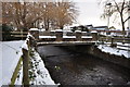
4
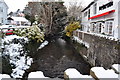
The view upstream from Caen Bridge on the river Caen
Image: © Roger A Smith
Taken: 20 Dec 2010
0.10 miles
5
The view downstream on the river Caen from a footbridge near the primary school
Image: © Roger A Smith
Taken: 20 Dec 2010
0.10 miles

7
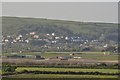
Looking across Chivenor Airfield towards West Hill, Braunton
Image: © Roger A Smith
Taken: 24 Apr 2011
0.11 miles
8
A footbridge on the river Caen near the primary school as seen from downstream
Image: © Roger A Smith
Taken: 20 Dec 2010
0.11 miles
9
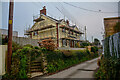
Braunton : Sharland's Lane
Looking along Sharland's Lane.
Image: © Lewis Clarke
Taken: 9 Jan 2021
0.11 miles