IMAGES TAKEN NEAR TO
Fairway Close, BRAUNTON, EX33 1EA
Introduction
This page details the photographs taken nearby to Fairway Close, EX33 1EA by members of the Geograph project.
The Geograph project started in 2005 with the aim of publishing, organising and preserving representative images for every square kilometre of Great Britain, Ireland and the Isle of Man.

There are currently over 7.5m images from over14,400 individuals and you can help contribute to the project by visiting https://www.geograph.org.uk
Image Map
Images are licensed for reuse under creativecommons.org/licenses/by-sa/2.0
Notes
- Clicking on the map will re-center to the selected point.
- The higher the marker number, the further away the image location is from the centre of the postcode.
Image Listing (13 Images Found)
Images are licensed for reuse under creativecommons.org/licenses/by-sa/2.0
Image
Details
Distance

2
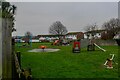
Braunton : Homer Road Playground
A play area on Homer Road.
Image: © Lewis Clarke
Taken: 9 Jan 2021
0.13 miles
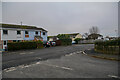
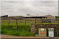
3

Entrance to Broadlands farm off Moor lane
Entrance to Broadlands farm off Moor lane
Image: © Shaun Ferguson
Taken: 2 Aug 2007
0.13 miles
4
Braunton : Homer Road
Looking along Homer Road from East Meadow Road.
Image: © Lewis Clarke
Taken: 9 Jan 2021
0.14 miles

6
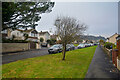
Braunton : Homer Road
Looking along Homer Road.
Image: © Lewis Clarke
Taken: 9 Jan 2021
0.16 miles
8
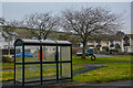
Braunton : Homer Road
Looking towards a bus stop on Homer Road.
Image: © Lewis Clarke
Taken: 9 Jan 2021
0.19 miles
9
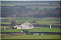
Braunton : Braunton Football Club
Looking down to the football club pavilion.
Image: © Lewis Clarke
Taken: 9 Jan 2021
0.20 miles
10
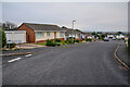
Braunton : East Meadow Road
Looking along East Meadow Road.
Image: © Lewis Clarke
Taken: 9 Jan 2021
0.21 miles