IMAGES TAKEN NEAR TO
Kingsacre, BRAUNTON, EX33 1BL
Introduction
This page details the photographs taken nearby to Kingsacre, EX33 1BL by members of the Geograph project.
The Geograph project started in 2005 with the aim of publishing, organising and preserving representative images for every square kilometre of Great Britain, Ireland and the Isle of Man.

There are currently over 7.5m images from over14,400 individuals and you can help contribute to the project by visiting https://www.geograph.org.uk
Image Map
Images are licensed for reuse under creativecommons.org/licenses/by-sa/2.0
Notes
- Clicking on the map will re-center to the selected point.
- The higher the marker number, the further away the image location is from the centre of the postcode.
Image Listing (14 Images Found)
Images are licensed for reuse under creativecommons.org/licenses/by-sa/2.0
Image
Details
Distance
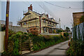
1
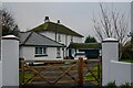
Braunton : Pixie Lane House
A house at 33 Pixie Lane.
Image: © Lewis Clarke
Taken: 9 Jan 2021
0.08 miles
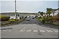
2
Braunton : Pixie Lane
Looking along Pixie Lane.
Image: © Lewis Clarke
Taken: 9 Jan 2021
0.10 miles
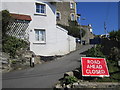
3
Braunton : Pixie Lane
Looking along Pixie Lane.
Image: © Lewis Clarke
Taken: 9 Jan 2021
0.11 miles
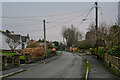
4
Saunton Road, Braunton
Looking towards Braunton village on a showery April morning.
Image: © Sue Sandy
Taken: 11 Apr 2008
0.16 miles
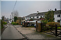
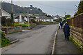
5
Braunton : Beech Grove
Looking along Beech Grove from Pixie Lane.
Image: © Lewis Clarke
Taken: 9 Jan 2021
0.17 miles
6
Braunton : Pixie Lane
Looking along Pixie Lane.
Image: © Lewis Clarke
Taken: 9 Jan 2021
0.18 miles
7
Braunton : Sharland's Lane
Looking along Sharland's Lane.
Image: © Lewis Clarke
Taken: 9 Jan 2021
0.18 miles
8
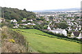
Looking down to Braunton
Looking down to Braunton from the lane below Buckland Cross
Image: © Shaun Ferguson
Taken: 3 Aug 2007
0.20 miles
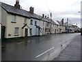
10
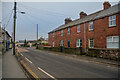
Braunton : Caen Street B3231
Looking along Caen Street.
Image: © Lewis Clarke
Taken: 9 Jan 2021
0.21 miles