IMAGES TAKEN NEAR TO
Aidan Avenue, BARNSTAPLE, EX32 9PH
Introduction
This page details the photographs taken nearby to Aidan Avenue, EX32 9PH by members of the Geograph project.
The Geograph project started in 2005 with the aim of publishing, organising and preserving representative images for every square kilometre of Great Britain, Ireland and the Isle of Man.

There are currently over 7.5m images from over14,400 individuals and you can help contribute to the project by visiting https://www.geograph.org.uk
Image Map
Images are licensed for reuse under creativecommons.org/licenses/by-sa/2.0
Notes
- Clicking on the map will re-center to the selected point.
- The higher the marker number, the further away the image location is from the centre of the postcode.
Image Listing (45 Images Found)
Images are licensed for reuse under creativecommons.org/licenses/by-sa/2.0
Image
Details
Distance
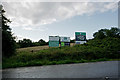
1
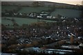
The Centre of this image is at the end of Aidan Avenue near the A361
Image: © Roger A Smith
Taken: 16 Feb 2016
0.02 miles
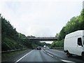
2
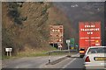
Barnstaple : The A361
The A361 heading around Barnstaple in North Devon.
Image: © Lewis Clarke
Taken: 3 Mar 2013
0.06 miles


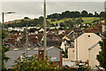
6

The Centre of this image is near the junction between the Landkey road and Woodford Gardens
Image: © Roger A Smith
Taken: 16 Feb 2016
0.14 miles
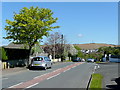
7

St. John's Lane 1
Looking south towards Landkey Road.
Image: © Jonathan Billinger
Taken: 12 May 2010
0.18 miles
8
St. John's Lane 2
On the left up ahead is Lampard Vachell School, for special needs.
The hill in the distance, with its radio mast, is above Fort Hill.
Image: © Jonathan Billinger
Taken: 12 May 2010
0.18 miles
10
Further imminent housing and retail developments beside the A361
Image: © Roger A Smith
Taken: 30 Jul 2017
0.19 miles