IMAGES TAKEN NEAR TO
Bishops Tawton Road, BARNSTAPLE, EX32 9EF
Introduction
This page details the photographs taken nearby to Bishops Tawton Road, EX32 9EF by members of the Geograph project.
The Geograph project started in 2005 with the aim of publishing, organising and preserving representative images for every square kilometre of Great Britain, Ireland and the Isle of Man.

There are currently over 7.5m images from over14,400 individuals and you can help contribute to the project by visiting https://www.geograph.org.uk
Image Map
Images are licensed for reuse under creativecommons.org/licenses/by-sa/2.0
Notes
- Clicking on the map will re-center to the selected point.
- The higher the marker number, the further away the image location is from the centre of the postcode.
Image Listing (40 Images Found)
Images are licensed for reuse under creativecommons.org/licenses/by-sa/2.0
Image
Details
Distance
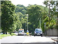
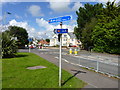
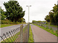
2
This bus route and cycle path would have once carried the Great Western Railway towards Barnstaple Junction
Image: © Roger A Smith
Taken: 18 Aug 2014
0.04 miles
3
The route of the old GWR line approaching the Bishops Tawton Road
The railway line passed underneath this road.
Image: © Roger A Smith
Taken: 18 Aug 2014
0.05 miles
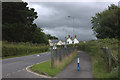
4
A location on the Bishops Tawton Road where the railway once passed underneath
Old maps indicate that the Great Western Railway between Vicarage Road station and Barnstaple Junction passed through a cutting underneath this road. The cyclepath which uses the route of the old railway now rises up to the level of the road. The bridge no longer exists.
Image: © Roger A Smith
Taken: 18 Aug 2014
0.06 miles
5
Cycle Route 3, Bishops Tawnton Road, Barnstaple
Image: © Jeff Gogarty
Taken: 8 Aug 2017
0.06 miles
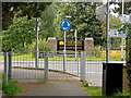
6
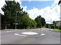
Mini-roundabout on the edge of Barnstaple
Image: © Jeff Gogarty
Taken: 8 Aug 2017
0.07 miles
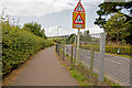
7
A cycle path leading away from the Bishops Tawton Road
The railway line followed the route of this path. However, the line ran beneath the road which indicates that the path has been raised to the level of the road.
Image: © Roger A Smith
Taken: 18 Aug 2014
0.07 miles
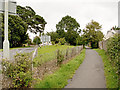
8
Road and cycle way near Park Community School
The school is to the left of the road. The cycle way is on the route of the old Great Western Railway line towards Taunton.
Image: © Robert Eva
Taken: 28 Jul 2017
0.09 miles
9
This bus route and cycle path would have once carried the Great Western Railway
Image: © Roger A Smith
Taken: 18 Aug 2014
0.09 miles
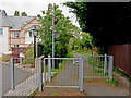
10
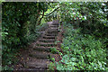
Steps on old railway path
The old railway embankment of this path ends abruptly but steps are provided for the walkers.
Image: © Robert Eva
Taken: 28 Jul 2017
0.13 miles