IMAGES TAKEN NEAR TO
Park Lane, BARNSTAPLE, EX32 9AL
Introduction
This page details the photographs taken nearby to Park Lane, EX32 9AL by members of the Geograph project.
The Geograph project started in 2005 with the aim of publishing, organising and preserving representative images for every square kilometre of Great Britain, Ireland and the Isle of Man.

There are currently over 7.5m images from over14,400 individuals and you can help contribute to the project by visiting https://www.geograph.org.uk
Image Map
Images are licensed for reuse under creativecommons.org/licenses/by-sa/2.0
Notes
- Clicking on the map will re-center to the selected point.
- The higher the marker number, the further away the image location is from the centre of the postcode.
Image Listing (104 Images Found)
Images are licensed for reuse under creativecommons.org/licenses/by-sa/2.0
Image
Details
Distance
1

Ordnance Survey Cut Mark
This OS cut mark can be found on the wall of No5 Prospect Place. It marks a point 18.983m above mean sea level.
Image: © Adrian Dust
Taken: 4 Jul 2016
0.01 miles
2

Near the middle of Park Lane
A brick wall is an uncommon sight along the lane. A benchmark has been made in it, courtesy of the Ordnanace Survey. See Image] for a closer look.
Image: © Neil Owen
Taken: 9 Jun 2023
0.01 miles
3
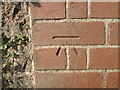
Brick wall benchmark
One of a few along Park Lane, this cutmark is listed in the Benchmark Database: https://www.bench-marks.org.uk/bm76695 . See Image] for a wider view.
Image: © Neil Owen
Taken: 9 Jun 2023
0.01 miles
4
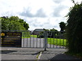
Gates to The Park, Community School on Park Lane
Barnstaple, Devon.
Image: © Jeff Gogarty
Taken: 8 Aug 2017
0.01 miles
5
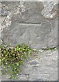
Ordnance Survey Cut Mark
This OS cut mark can be found on the NW wall of Prospect Place. It marks a point 20.854m above mean sea level.
Image: © Adrian Dust
Taken: 4 Jul 2016
0.05 miles

7

St John the Baptist church, Newport, Barnstaple
Image: © Robert Eva
Taken: 28 Jul 2017
0.10 miles

9
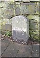
Old Milestone, B3138 (Former A377), South Street, Barnstaple
The milestone is located just north of the junction with Park Lane, on the path beside the wall, on the west side of the road. Parish of Barnstaple (North Devon District). Carved stone post, Barum tombstone design, erected by the Barnstaple turnpike trust in the 19th century.
Inscription reads:-
1 / BARUM
Grade II Listed. List Entry Number: 1385341 https://historicengland.org.uk/listing/the-list/list-entry/1385341
Milestone Society National ID: DV_EXBS39
Image: © Alan Rosevear
Taken: 8 Feb 2013
0.10 miles
10

South Street at the top of Park Lane, Barnstaple
Image: © Jeff Gogarty
Taken: 8 Aug 2017
0.10 miles