IMAGES TAKEN NEAR TO
BARNSTAPLE, EX32 9AF
Introduction
This page details the photographs taken nearby to EX32 9AF by members of the Geograph project.
The Geograph project started in 2005 with the aim of publishing, organising and preserving representative images for every square kilometre of Great Britain, Ireland and the Isle of Man.

There are currently over 7.5m images from over14,400 individuals and you can help contribute to the project by visiting https://www.geograph.org.uk
Image Map (Loading...)


Getting Data...Please wait
Leaflet Map data © OpenStreetMap
Images are licensed for reuse under creativecommons.org/licenses/by-sa/2.0
Notes
- Clicking on the map will re-center to the selected point.
- The higher the marker number, the further away the image location is from the centre of the postcode.
Image Listing (310 Images Found)
Images are licensed for reuse under creativecommons.org/licenses/by-sa/2.0
Image
Details
Distance
2
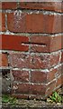
Ordnance Survey Cut Mark
This OS cut mark can be found on the Rock Park Lodge. It marks a point 5.127m above mean sea level.
Image: © Adrian Dust
Taken: 4 Jul 2016
0.03 miles
4
Ordnance Survey Cut Mark
This OS cut mark can be found on the wall of No6 Victoria Terrace. It marks a point 5.377m above mean sea level.
Image: © Adrian Dust
Taken: 4 Jul 2016
0.04 miles
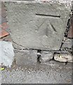
5
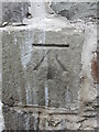
Benchmark on Victoria Road
This cutmark is on Victoria Terrace, facing onto Victoria Road, Barnstaple. See https://www.bench-marks.org.uk/bm35824 for the entry in the Benchmark Database and Image] for a wider view of the gateway.
Image: © Neil Owen
Taken: 9 Jun 2023
0.04 miles

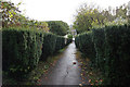
8
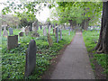
Footpath through the churchyard
This path is only open during the daytime.
Image: © Row17
Taken: 13 Apr 2011
0.04 miles
9
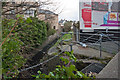
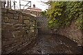
Looking upstream on Coney Gut from Newport Road
At this point the stream continues under Rock Park and into the River Taw.
Image: © Roger A Smith
Taken: 7 Jan 2012
0.04 miles
10
Coney Gut entering a tunnel under Newport Road
This tunnel runs under Rock Park and discharges into the River Taw.
Image: © Roger A Smith
Taken: 7 Jan 2012
0.04 miles