IMAGES TAKEN NEAR TO
Victoria Road, BARNSTAPLE, EX32 8NP
Introduction
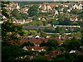
This page details the photographs taken nearby to Victoria Road, EX32 8NP by members of the Geograph project.
The Geograph project started in 2005 with the aim of publishing, organising and preserving representative images for every square kilometre of Great Britain, Ireland and the Isle of Man.

There are currently over 7.5m images from over14,400 individuals and you can help contribute to the project by visiting https://www.geograph.org.uk
Image Map
Images are licensed for reuse under creativecommons.org/licenses/by-sa/2.0
Notes
- Clicking on the map will re-center to the selected point.
- The higher the marker number, the further away the image location is from the centre of the postcode.
Image Listing (101 Images Found)
Images are licensed for reuse under creativecommons.org/licenses/by-sa/2.0
Image
Details
Distance
1

Ordnance Survey Cut Mark
This OS cut mark can be found on the wall of Laurel House on Barbican Lane. It marks a point 16.691m above mean sea level.
Image: © Adrian Dust
Taken: 4 Jul 2016
0.03 miles
2

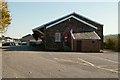
The western end of Grosvenor Church formerly a railway building
Image: © Roger A Smith
Taken: 16 Jun 2016
0.05 miles
3
Grosvenor Church surrounded by houses in Newport & Barnstaple
Rooftops in Newport are in the foreground. The roof of the Grosvenor Church is in the centre. At the top of the image, standing out in the centre, is Garron Court, Sowden Lane.
Image: © Roger A Smith
Taken: 9 Jun 2020
0.05 miles
4

The southern side of Grosvenor Church formerly a railway building
Image: © Roger A Smith
Taken: 16 Jun 2016
0.05 miles
5
Grosvenor Church on the site of the old Victoria Road Railway Terminus
Image: © Roger A Smith
Taken: 22 Oct 2011
0.05 miles
6

Ordnance Survey Cut Mark
This OS cut mark can be found on an outbuilding of No1 Sunny Bank. It marks a point 14.377m above mean sea level.
Image: © Adrian Dust
Taken: 4 Jul 2016
0.06 miles
7

The northerly facing side of Grosvenor Church formerly a railway building
Image: © Roger A Smith
Taken: 16 Jun 2016
0.06 miles
8

The main entrance into Grosvenor Church formerly a railway building
Image: © Roger A Smith
Taken: 16 Jun 2016
0.06 miles
9
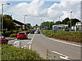
Eastern Avenue approaching the site of the Victoria Road railway station
The station was on the right, where Eastern Power Distribution now have a depot. An original building still remains on the left and is now the Grosvenor church.
Image: © Roger A Smith
Taken: 18 Aug 2014
0.06 miles
10

The southern side of Grosvenor Church formerly a railway building
Image: © Roger A Smith
Taken: 16 Jun 2016
0.06 miles