
IMAGES TAKEN NEAR TO
Litchdon Lane, BARNSTAPLE, EX32 8NL
Introduction
This page details the photographs taken nearby to Litchdon Lane, EX32 8NL by members of the Geograph project.
The Geograph project started in 2005 with the aim of publishing, organising and preserving representative images for every square kilometre of Great Britain, Ireland and the Isle of Man.

There are currently over 7.5m images from over14,400 individuals and you can help contribute to the project by visiting https://www.geograph.org.uk
Image Map
Images are licensed for reuse under creativecommons.org/licenses/by-sa/2.0
Notes
- Clicking on the map will re-center to the selected point.
- The higher the marker number, the further away the image location is from the centre of the postcode.
Image Listing (917 Images Found)
Images are licensed for reuse under creativecommons.org/licenses/by-sa/2.0
Image
Details
Distance
1
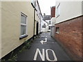
Litchdon Lane, Barnstaple
From Litchdon Street along Litchdon Lane towards Taw Vale and the River Taw.
Image: © Jaggery
Taken: 24 Jun 2017
0.00 miles

3

Former Litchdon Street Pottery, Barnstaple
This was Brannam's Pottery that closed in 1979. These buildings date at least in part from 1886-7. There is a preserved bottle oven in the yard behind that is noe part of a medical centre. These buildings are Listed Grade II.
Image: © Chris Allen
Taken: 23 Apr 2013
0.01 miles
4
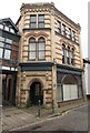
Former Brannam's Pottery, Litchdon Street, Barnstaple
A blue plaque http://www.geograph.org.uk/photo/5475183 is on the wall near the doorway.
The pottery which dates from at least 1830,
possibly much earlier, was acquired before 1840
by the Brannam family who ran it until 1979.
The former pottery is Grade II listed.
Image: © Jaggery
Taken: 24 Jun 2017
0.01 miles
5
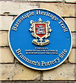
Brannam's Pottery Site blue plaque, Barnstaple
The Barnstaple Heritage Trail blue plaque is on the wall here. http://www.geograph.org.uk/photo/5475180
Image: © Jaggery
Taken: 24 Jun 2017
0.01 miles
6
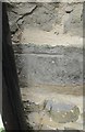
Ordnance Survey Cut Mark
This OS cut mark can be found on the Penrose Almshouses. It marks a point 7.245m above mean sea level.
Image: © Adrian Dust
Taken: 4 Jul 2016
0.02 miles
7
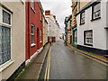
Barnstaple : Litchdon Street
Looking along Litchdon Street.
Image: © Lewis Clarke
Taken: 19 Feb 2021
0.02 miles
8

Acupuncture clinic, 30 Litchdon Street, Barnstaple
Text on a window shows TRADITIONAL CHINESE ACUPUNCTURE CLINIC.
Acupuncture is a therapy involving the insertion of needles (very thin, fine, sterilised, disposable and single-use) into acupuncture points of the body to stimulate invisible channels of qi. In Chinese medicine, qi (pronounced chee) is a person's life-force, the free flow of which within the body is believed to ensure physical and spiritual health.
Image: © Jaggery
Taken: 24 Jun 2017
0.02 miles
9

Bertie's Hairdressers, Litchdon Street, Barnstaple
This is one of the former location of Branham's Pottery.
http://www.britishlistedbuildings.co.uk/en-485664-litchdon-pottery-including-bottle-kilns-
Image: © Roger A Smith
Taken: 24 Aug 2011
0.02 miles
10
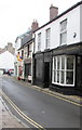
Adams Antiques of Barnstaple
Antiques shop at 10 Litchdon Street.
Double yellow lines on both sides
indicate no parking at any time.
Image: © Jaggery
Taken: 24 Jun 2017
0.02 miles