IMAGES TAKEN NEAR TO
Bevan Road, BARNSTAPLE, EX32 8LQ
Introduction
This page details the photographs taken nearby to Bevan Road, EX32 8LQ by members of the Geograph project.
The Geograph project started in 2005 with the aim of publishing, organising and preserving representative images for every square kilometre of Great Britain, Ireland and the Isle of Man.

There are currently over 7.5m images from over14,400 individuals and you can help contribute to the project by visiting https://www.geograph.org.uk
Image Map
Images are licensed for reuse under creativecommons.org/licenses/by-sa/2.0
Notes
- Clicking on the map will re-center to the selected point.
- The higher the marker number, the further away the image location is from the centre of the postcode.
Image Listing (212 Images Found)
Images are licensed for reuse under creativecommons.org/licenses/by-sa/2.0
Image
Details
Distance
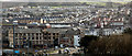
1
In the centre of the image is Fort Hill
In the foreground is Bridge Wharf. The Strand runs from left to right in the midground.
Image: © Roger A Smith
Taken: 25 Mar 2015
0.07 miles
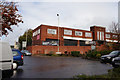
2
Ashley Primary School As Seen From Alexandra Road
Image: © Roger A Smith
Taken: 15 Feb 2012
0.08 miles
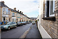
3
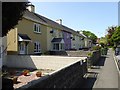
Terraced houses, Oakleigh Road, Barnstaple
Image: © David Smith
Taken: 24 May 2016
0.08 miles
4
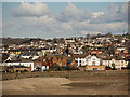
A panoramic view of the East of Barnstaple
In the centre of the image is Fort Street ascending away to the right. To the left of centre is Alexandra Court with its arched entrance. In the top left are houses on Jewell Crescent. Gorwell road stretches 3/4 of the way across from Jewell Crescent to Upper Gorwell house. Below Gorwell House and to the right of Fort Street is the Army Reserve Centre.
In the foreground are the old buildings of the Shapland company on Bridge Wharf. In the bottom centre A minor collision has occurred on the A3125 (see: Image)
Image: © Roger A Smith
Taken: 30 Mar 2015
0.09 miles
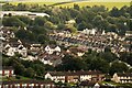
6

The centre of this road is around Ashley road
The mast at Maidenford is visible to the right and houses in Goodleigh can be seen right of centre. The hills in the distance are around Simonsbath.
Image: © Roger A Smith
Taken: 2 May 2020
0.09 miles
8
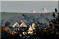
A property on the corner of Ashleigh Road & Sowden Lane
Tutshill woods is beyond this house with turbines near Metcombe Down and Swindon Down on the horizon.
Image: © Roger A Smith
Taken: 2 Nov 2016
0.09 miles
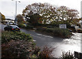
9
Army Reserve Centre
On Belle Meadow Road, Barnstaple.
Image: © Ian S
Taken: 7 Nov 2015
0.09 miles
10
The centre of this image is on Hills View
In the top left is the Tarka Leisure building. The foreground is occupied by houses on Belmont Road.
Image: © Roger A Smith
Taken: 27 Aug 2023
0.10 miles