IMAGES TAKEN NEAR TO
Gould Road, BARNSTAPLE, EX32 8ER
Introduction
This page details the photographs taken nearby to Gould Road, EX32 8ER by members of the Geograph project.
The Geograph project started in 2005 with the aim of publishing, organising and preserving representative images for every square kilometre of Great Britain, Ireland and the Isle of Man.

There are currently over 7.5m images from over14,400 individuals and you can help contribute to the project by visiting https://www.geograph.org.uk
Image Map (Loading...)


Getting Data...Please wait
Leaflet Map data © OpenStreetMap
Images are licensed for reuse under creativecommons.org/licenses/by-sa/2.0
Notes
- Clicking on the map will re-center to the selected point.
- The higher the marker number, the further away the image location is from the centre of the postcode.
Image Listing (51 Images Found)
Images are licensed for reuse under creativecommons.org/licenses/by-sa/2.0
Image
Details
Distance
1

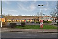
Winter rain outside Wickes in Barnstaple
Image: © Roger A Smith
Taken: 8 Dec 2019
0.07 miles
2
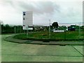
Wickes of Barnstaple on the Whiddon Valley Industrial Estate
Image: © Roger A Smith
Taken: 7 Jan 2012
0.07 miles
4
Coney Gut where it passes through a sluice gate
This gate is just downstream from a storm overflow tunnel which passes under Newport.
Image: © Roger A Smith
Taken: 7 Jan 2012
0.11 miles
5
This path follows the route of the old GWR line to Victoria Road Station
Image: © Roger A Smith
Taken: 18 Aug 2014
0.11 miles
6
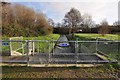
A sluice gate on Coney Gut just downstream from the storm overflow tunnel
Image: © Roger A Smith
Taken: 7 Jan 2012
0.11 miles
7
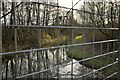
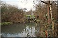
The view downstream on Coney Gut from a footbridge near Rose Lane
The channel to the left leads to a weir and storm tunnel.
Image: © Roger A Smith
Taken: 7 Jan 2012
0.11 miles
8

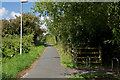
A cyclepath leaving Eastern Avenue along the route of the old GWR line to Barnstaple Junction
Image: © Roger A Smith
Taken: 18 Aug 2014
0.11 miles
9
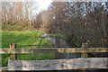
The weir and storm tunnel which serve as flood relief for Coney Gut
Image: © Roger A Smith
Taken: 7 Jan 2012
0.12 miles
10

The cyclepath which follows the route of the old GWR line reaches Eastern Avenue
Eastern Avenue was built on the site of the railway after it closed.
Image: © Roger A Smith
Taken: 18 Aug 2014
0.12 miles