IMAGES TAKEN NEAR TO
Firs Grove, BARNSTAPLE, EX32 8BX
Introduction
This page details the photographs taken nearby to Firs Grove, EX32 8BX by members of the Geograph project.
The Geograph project started in 2005 with the aim of publishing, organising and preserving representative images for every square kilometre of Great Britain, Ireland and the Isle of Man.

There are currently over 7.5m images from over14,400 individuals and you can help contribute to the project by visiting https://www.geograph.org.uk
Image Map
Images are licensed for reuse under creativecommons.org/licenses/by-sa/2.0
Notes
- Clicking on the map will re-center to the selected point.
- The higher the marker number, the further away the image location is from the centre of the postcode.
Image Listing (43 Images Found)
Images are licensed for reuse under creativecommons.org/licenses/by-sa/2.0
Image
Details
Distance
1
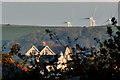
A property on the corner of Ashleigh Road & Sowden Lane
Tutshill woods is beyond this house with turbines near Metcombe Down and Swindon Down on the horizon.
Image: © Roger A Smith
Taken: 2 Nov 2016
0.10 miles
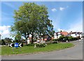
2

The centre of this road is around Ashley road
The mast at Maidenford is visible to the right and houses in Goodleigh can be seen right of centre. The hills in the distance are around Simonsbath.
Image: © Roger A Smith
Taken: 2 May 2020
0.13 miles
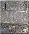
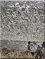
3

Ordnance Survey Cut Mark
This OS cut mark can be found on the wall of Laurel House on Barbican Lane. It marks a point 16.691m above mean sea level.
Image: © Adrian Dust
Taken: 4 Jul 2016
0.13 miles
4

Haynes Park and Constitution Hill
The two roads visible are Haynes Park and Constitution Hill. Ravelin Manor is in the upper right corner.
Image: © Roger A Smith
Taken: 9 Jun 2020
0.15 miles
5
Ordnance Survey Cut Mark
This OS cut mark can be found at the entrance to the cemetery. It marks a point 35.845m above mean sea level.
Image: © Adrian Dust
Taken: 8 Jul 2016
0.16 miles
6
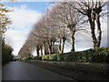
Pollarded trees line the cemetery, on Goodleigh Road
Image: © Roger Cornfoot
Taken: 22 Nov 2014
0.16 miles
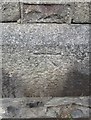
7

Ordnance Survey Cut Mark
This OS cut mark can be found on an outbuilding of No1 Sunny Bank. It marks a point 14.377m above mean sea level.
Image: © Adrian Dust
Taken: 4 Jul 2016
0.16 miles
8
Ordnance Survey Cut Mark
This OS cut mark can be found on the SW corner post of the cemetery. It marks a point 33.662m above mean sea level.
Image: © Adrian Dust
Taken: 8 Jul 2016
0.16 miles
10
Ordnance Survey Cut Mark
This OS cut mark can be found on the SE corner post of the cemetery. It marks a point 15.554m above mean sea level.
Image: © Adrian Dust
Taken: 8 Jul 2016
0.17 miles