IMAGES TAKEN NEAR TO
Litchdon Street, BARNSTAPLE, EX32 8AY
Introduction
This page details the photographs taken nearby to Litchdon Street, EX32 8AY by members of the Geograph project.
The Geograph project started in 2005 with the aim of publishing, organising and preserving representative images for every square kilometre of Great Britain, Ireland and the Isle of Man.

There are currently over 7.5m images from over14,400 individuals and you can help contribute to the project by visiting https://www.geograph.org.uk
Image Map
Images are licensed for reuse under creativecommons.org/licenses/by-sa/2.0
Notes
- Clicking on the map will re-center to the selected point.
- The higher the marker number, the further away the image location is from the centre of the postcode.
Image Listing (896 Images Found)
Images are licensed for reuse under creativecommons.org/licenses/by-sa/2.0
Image
Details
Distance
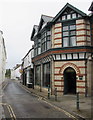
1
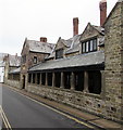
Penrose Almshouses, Litchdon Street, Barnstaple
Originally twenty dwellings, each for two inmates of the same sex, completed in 1627, three years after the death of the founder, John Penrose. Later repair and refurbishment includes 20th century replanning with partial conversion to flats and some features copying the original. Pevsner states that this is a remarkably attractive and ambitious early 17th century complex, and is the finest of a notable group of almshouses in Barnstaple.
Grade I listed in 1951.
Image: © Jaggery
Taken: 24 Jun 2017
0.02 miles
2
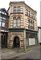
Former Brannam's Pottery, Litchdon Street, Barnstaple
A blue plaque http://www.geograph.org.uk/photo/5475183 is on the wall near the doorway.
The pottery which dates from at least 1830,
possibly much earlier, was acquired before 1840
by the Brannam family who ran it until 1979.
The former pottery is Grade II listed.
Image: © Jaggery
Taken: 24 Jun 2017
0.02 miles
3
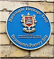
Brannam's Pottery Site blue plaque, Barnstaple
The Barnstaple Heritage Trail blue plaque is on the wall here. http://www.geograph.org.uk/photo/5475180
Image: © Jaggery
Taken: 24 Jun 2017
0.02 miles
4
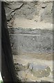
Ordnance Survey Cut Mark
This OS cut mark can be found on the Penrose Almshouses. It marks a point 7.245m above mean sea level.
Image: © Adrian Dust
Taken: 4 Jul 2016
0.02 miles
5
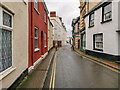
Barnstaple : Litchdon Street
Looking along Litchdon Street.
Image: © Lewis Clarke
Taken: 19 Feb 2021
0.02 miles
6
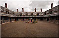
Penrose Almshouses, Litchdon Street, Barnstaple
Completed in 1627.
Image: © Roger A Smith
Taken: 24 Aug 2011
0.02 miles
7
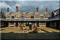
Barnstaple : Penrose's Almshouses
17th-century almshouses in Litchdon Street, built in memory of John Penrose (1575–1624), a merchant and Mayor of Barnstaple. They have been a Grade I listed building since 1951.
Image: © Lewis Clarke
Taken: 21 Sep 2021
0.02 miles
8
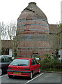
Bottle oven - Brannam Medical Centre
This is on part of the site of the Litchdon street Pottery of C H Brannam Ltd and the bottle oven or bottle kiln has been relocated to the rear of the medical centre. It doesn't appear to be of the type found in the Potteries with a separate hovel but I didn't inspect too closely. This area is the helath centre's car park.
Image: © Chris Allen
Taken: 23 Apr 2013
0.02 miles
9
Bertie's hairdressers, Litchdon Street, Barnstaple
This is one of the former location of Branham's Pottery.
http://www.britishlistedbuildings.co.uk/en-485664-litchdon-pottery-including-bottle-kilns-
Image: © Roger A Smith
Taken: 24 Aug 2011
0.02 miles
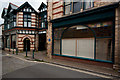
10
Berties, Barnstaple
Unisex hairdressers at 11 Litchdon Street.
Double yellow lines on both sides of the street indicate no parking at any time.
Image: © Jaggery
Taken: 24 Jun 2017
0.02 miles