IMAGES TAKEN NEAR TO
Hawley Close, BARNSTAPLE, EX32 8AR
Introduction
This page details the photographs taken nearby to Hawley Close, EX32 8AR by members of the Geograph project.
The Geograph project started in 2005 with the aim of publishing, organising and preserving representative images for every square kilometre of Great Britain, Ireland and the Isle of Man.

There are currently over 7.5m images from over14,400 individuals and you can help contribute to the project by visiting https://www.geograph.org.uk
Image Map
Images are licensed for reuse under creativecommons.org/licenses/by-sa/2.0
Notes
- Clicking on the map will re-center to the selected point.
- The higher the marker number, the further away the image location is from the centre of the postcode.
Image Listing (7 Images Found)
Images are licensed for reuse under creativecommons.org/licenses/by-sa/2.0
Image
Details
Distance
3

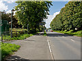
Haynes Park and Constitution Hill
The two roads visible are Haynes Park and Constitution Hill. Ravelin Manor is in the upper right corner.
Image: © Roger A Smith
Taken: 9 Jun 2020
0.17 miles
5
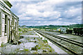
Barnstaple GWR station, 1969
Closed for passenger traffic, the goods yard was still open in 1969. Now all swept away and replaced by a re-routed A39 and much else.
Image: © Robin Webster
Taken: Unknown
0.24 miles
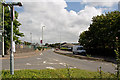
6
Eastern Avenue, the route of the GWR line into Victoria Road Station
The line from Barnstaple junction would have joined from the left, currently a cyclepath.
Image: © Roger A Smith
Taken: 18 Aug 2014
0.24 miles
7
Eastern Avenue where once stood the Victoria Road railway station
The station building stood on or to the left of the present road.
Image: © Roger A Smith
Taken: 18 Aug 2014
0.24 miles