IMAGES TAKEN NEAR TO
Brayford, BARNSTAPLE, EX32 7PZ
Introduction
This page details the photographs taken nearby to EX32 7PZ by members of the Geograph project.
The Geograph project started in 2005 with the aim of publishing, organising and preserving representative images for every square kilometre of Great Britain, Ireland and the Isle of Man.

There are currently over 7.5m images from over14,400 individuals and you can help contribute to the project by visiting https://www.geograph.org.uk
Image Map
Images are licensed for reuse under creativecommons.org/licenses/by-sa/2.0
Notes
- Clicking on the map will re-center to the selected point.
- The higher the marker number, the further away the image location is from the centre of the postcode.
Image Listing (3 Images Found)
Images are licensed for reuse under creativecommons.org/licenses/by-sa/2.0
Image
Details
Distance
1

Middlecott
A farm west of Hudley Mill on the land to Goodwells Head.
Image: © Derek Harper
Taken: 22 Jun 2019
0.01 miles
2
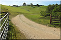
Track to Middlecott Wood
A private track leaving Middlecott Hill west of Hudley Mill. The farm at Middlecott appears from this vantage point to be on a hilltop, but isn't.
Image: © Derek Harper
Taken: 22 Jun 2019
0.19 miles
3

Grass field on Middlecott Hill
From one of the right-angled bends on the lane from Goodwells Head to Hudley Mill.
Image: © Derek Harper
Taken: 22 Jun 2019
0.25 miles