IMAGES TAKEN NEAR TO
Brayford, BARNSTAPLE, EX32 7PL
Introduction
This page details the photographs taken nearby to EX32 7PL by members of the Geograph project.
The Geograph project started in 2005 with the aim of publishing, organising and preserving representative images for every square kilometre of Great Britain, Ireland and the Isle of Man.

There are currently over 7.5m images from over14,400 individuals and you can help contribute to the project by visiting https://www.geograph.org.uk
Image Map
Images are licensed for reuse under creativecommons.org/licenses/by-sa/2.0
Notes
- Clicking on the map will re-center to the selected point.
- The higher the marker number, the further away the image location is from the centre of the postcode.
Image Listing (8 Images Found)
Images are licensed for reuse under creativecommons.org/licenses/by-sa/2.0
Image
Details
Distance
1
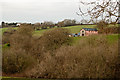
The Old Granary, Furze Farm, Brayford
Image: © Roger A Smith
Taken: 16 Jan 2013
0.02 miles
2
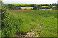
Countryside near Stone
From a gateway on the other side of the farm lane shown in Image Mature trees enclose fields around a headwater of the Venn Brook.
Image: © Derek Harper
Taken: 22 Jun 2019
0.11 miles

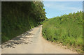
4

Farm lane to Furze
Image: © Derek Harper
Taken: 22 Jun 2019
0.18 miles
5

Lane to Stone Cross
Image: © Derek Harper
Taken: 22 Jun 2019
0.18 miles
6
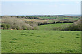
Swimbridge: near Stone Cross
Looking south east. The plume of smoke on the left indicates the site of the chipboard factory near South Molton
Image: © Martin Bodman
Taken: 18 Apr 2007
0.18 miles
7
Lane to Whitsford
Image: © Derek Harper
Taken: 22 Jun 2019
0.19 miles
8
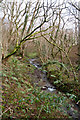
Possibly very close to the source of Venn Stream
As with many streams and small rivers this stream is marked on maps up to a certain location. Beyond that several other waterways feed into each other. Which of these is Venn Stream is unclear.
Image: © Roger A Smith
Taken: 16 Jan 2013
0.19 miles