IMAGES TAKEN NEAR TO
Brayford, BARNSTAPLE, EX32 7PJ
Introduction
This page details the photographs taken nearby to EX32 7PJ by members of the Geograph project.
The Geograph project started in 2005 with the aim of publishing, organising and preserving representative images for every square kilometre of Great Britain, Ireland and the Isle of Man.

There are currently over 7.5m images from over14,400 individuals and you can help contribute to the project by visiting https://www.geograph.org.uk
Image Map (Loading...)


Getting Data...Please wait
Leaflet Map data © OpenStreetMap
Images are licensed for reuse under creativecommons.org/licenses/by-sa/2.0
Notes
- Clicking on the map will re-center to the selected point.
- The higher the marker number, the further away the image location is from the centre of the postcode.
Image Listing (4 Images Found)
Images are licensed for reuse under creativecommons.org/licenses/by-sa/2.0
Image
Details
Distance
1
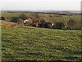
Accott
Accott seen from the lane crossing Hutcherton Down between Stone Cross and Gunn Cross. The following history is taken from http://www.uklanddirectory.org.uk/land-for-sale.asp?id=2963 (no longer available) : "Accott Manor is believed to date from the 12th century and although the original manor house fell derelict in the 1950's the detached Grade II Listed private chapel adjoining is in sound condition…. Accott is reputed to be named after Acca, a local Saxon landowner who also gave his name to Ackland, Landkey. The Manor which comprised several farms originally formed part of the episcopal manor of Bishops Tawton and has quite a long history. According to another document Accott was held by Richard Cotell of Drogo de Lington in 1127, whose ancestors had been granted the estate by a Bishop of Exeter. A century and a half later Alice Cotell gave it in exchange for a "sore goshawk" and a life annuity to John Giffard, whose family owned it for about another century. The estate left the Giffard family eventually when it was sold by three sisters who had inherited it jointly when their two brothers, who were wild characters, had killed each other in a quarrel. The Chichester family of Hall owned the farm for over 300 years until the early 1900's. At the western end of the manor house is a chapel used for Roman Catholic services when the Giffards lived there in the late 1500's after the dissolution of the monasteries by Henry VIII.
In 1890, during repairs to the house, workmen removed some cannon balls which were embedded in the walls. These seemed to indicate that Accott may have been the scene of an engagement, probably during the Civil War of the 1650's.
Soon after the Chichester Estate had to sell off Accott for Estate Duty reasons and both farms were bought by the Lee family. Since they only needed one house to live in the manor house was used for storage purposes."
The buildings are better seen from SS6431.
Image: © Derek Harper
Taken: 23 Nov 2007
0.01 miles
2
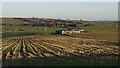
Farm building near Accott
Sunlight highlights rows of stubble on this plateau-like area immediately north of Image But appearances are deceptive; two deep valleys, the first of them the valley of the River Venn, lie between the corrugated iron barn and the buildings at Middle Stoodleigh, which are in SS6532. The line of sight cuts across the view in the background of Image, in which the valleys are clearly seen.
Image: © Derek Harper
Taken: 23 Nov 2007
0.16 miles
4
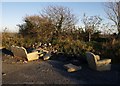
Comfy layby
Sofas, tyres and debris grace a laneside layby at the top of the farm road down to Accott.
Image: © Derek Harper
Taken: 23 Nov 2007
0.21 miles