IMAGES TAKEN NEAR TO
Berry Lane, BARNSTAPLE, EX32 7PG
Introduction
This page details the photographs taken nearby to Berry Lane, EX32 7PG by members of the Geograph project.
The Geograph project started in 2005 with the aim of publishing, organising and preserving representative images for every square kilometre of Great Britain, Ireland and the Isle of Man.

There are currently over 7.5m images from over14,400 individuals and you can help contribute to the project by visiting https://www.geograph.org.uk
Image Map
Images are licensed for reuse under creativecommons.org/licenses/by-sa/2.0
Notes
- Clicking on the map will re-center to the selected point.
- The higher the marker number, the further away the image location is from the centre of the postcode.
Image Listing (12 Images Found)
Images are licensed for reuse under creativecommons.org/licenses/by-sa/2.0
Image
Details
Distance

4
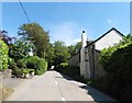
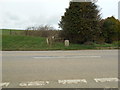
Berry Lane, Gunn
Forms a small crescent dropping of the main road.
Image: © Anthony Vosper
Taken: 9 Mar 2019
0.06 miles
6
5 miles to Barnstaple
Viewed from across the road .
An OS Bench Mark is located on it.
Details can be found on Image
Image: © Anthony Vosper
Taken: 9 Mar 2019
0.07 miles
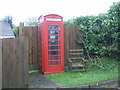
7
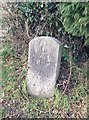
Old Milestone by Goodleigh Road, Gunn, Swimbridge Parish
Carved stone post by the UC road, in parish of SWIMBRIDGE (NORTH DEVON District), Goodleigh Road, Gunn, opposite Berry Lane and post box, at end of shrubbery, by fence, on North side of road. Barum tombstone, erected by the Barnstaple turnpike trust in the 19th century.
Inscription reads:-
5
BARUM
Carved benchmark on lower face.
Devon & Dartmoor HER listed. HER Number: MDV72449
https://www.heritagegateway.org.uk/Gateway/Results_Single.aspx?uid=MDV72449&resourceID=104
Milestone Society National ID: DV_BSIFg05.
Image: © A Rosevear
Taken: 8 Feb 2013
0.08 miles
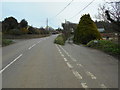
8
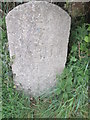
Milestone - Barnstaple 5
There is an OS cut mark on the milestone. It marks a point 198.093m above mean sea level.
Image: © Adrian Dust
Taken: 23 Apr 2015
0.08 miles

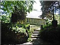
10
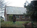
Church of the Holy Name, Gunn
Taken from the North-East.
Image: © Grant Sherman
Taken: 11 Mar 2005
0.09 miles