IMAGES TAKEN NEAR TO
Gunn, Goodleigh, BARNSTAPLE, EX32 7NZ
Introduction
This page details the photographs taken nearby to EX32 7NZ by members of the Geograph project.
The Geograph project started in 2005 with the aim of publishing, organising and preserving representative images for every square kilometre of Great Britain, Ireland and the Isle of Man.

There are currently over 7.5m images from over14,400 individuals and you can help contribute to the project by visiting https://www.geograph.org.uk
Image Map
Images are licensed for reuse under creativecommons.org/licenses/by-sa/2.0
Notes
- Clicking on the map will re-center to the selected point.
- The higher the marker number, the further away the image location is from the centre of the postcode.
Image Listing (4 Images Found)
Images are licensed for reuse under creativecommons.org/licenses/by-sa/2.0
Image
Details
Distance
1

Bridleway junction in Higher Dean Wood
Image: © Roger Cornfoot
Taken: 10 Jun 2019
0.17 miles
2
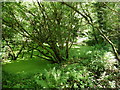
Abandoned fish pond in Higher Dean Wood
Image: © Roger Cornfoot
Taken: 10 Jun 2019
0.20 miles

4

Entrance to Tree Beach Rural Enterprise Park, Gunn
Land north of Tree Beach Farm has been developed to give workshops and light industry
Image: © David Smith
Taken: 22 Mar 2019
0.24 miles