IMAGES TAKEN NEAR TO
Goodleigh, BARNSTAPLE, EX32 7NA
Introduction
This page details the photographs taken nearby to EX32 7NA by members of the Geograph project.
The Geograph project started in 2005 with the aim of publishing, organising and preserving representative images for every square kilometre of Great Britain, Ireland and the Isle of Man.

There are currently over 7.5m images from over14,400 individuals and you can help contribute to the project by visiting https://www.geograph.org.uk
Image Map (Loading...)


Getting Data...Please wait
Leaflet Map data © OpenStreetMap
Images are licensed for reuse under creativecommons.org/licenses/by-sa/2.0
Notes
- Clicking on the map will re-center to the selected point.
- The higher the marker number, the further away the image location is from the centre of the postcode.
Image Listing (13 Images Found)
Images are licensed for reuse under creativecommons.org/licenses/by-sa/2.0
Image
Details
Distance

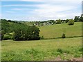
8

Towards Goodleigh
A view to the Coney Gut valley and the village (mostly in Image) from the lane between Hall Farm and Willesleigh Cross.
Image: © Derek Harper
Taken: 8 Feb 2010
0.21 miles
9

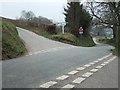
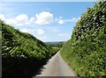
Road descending west to Willesleigh
This is part of NCN3
Image: © David Smith
Taken: 22 Mar 2019
0.22 miles
10

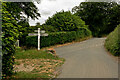
Landkey: Joy Cross
Looking west on the lane to Maidenford with Barnstaple and the river Taw visible near the horizon
Image: © Martin Bodman
Taken: 18 Apr 2007
0.22 miles