IMAGES TAKEN NEAR TO
Beaufort Walk, BARNSTAPLE, EX32 7JB
Introduction
This page details the photographs taken nearby to Beaufort Walk, EX32 7JB by members of the Geograph project.
The Geograph project started in 2005 with the aim of publishing, organising and preserving representative images for every square kilometre of Great Britain, Ireland and the Isle of Man.

There are currently over 7.5m images from over14,400 individuals and you can help contribute to the project by visiting https://www.geograph.org.uk
Image Map (Loading...)


Getting Data...Please wait
Leaflet Map data © OpenStreetMap
Images are licensed for reuse under creativecommons.org/licenses/by-sa/2.0
Notes
- Clicking on the map will re-center to the selected point.
- The higher the marker number, the further away the image location is from the centre of the postcode.
Image Listing (24 Images Found)
Images are licensed for reuse under creativecommons.org/licenses/by-sa/2.0
Image
Details
Distance
1
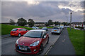
Barnstaple : Derby Road
A residential road in the suburbs.
Image: © Lewis Clarke
Taken: 29 Oct 2021
0.05 miles
2
Barnstaple : Derby Road
A residentail road in Barnstaple.
Image: © Lewis Clarke
Taken: 29 Oct 2021
0.05 miles
3

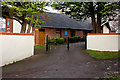
Barnstaple : Kingdom Hall of Jehovah's Witnesses
A Kingdom Hall on Derby Road.
Image: © Lewis Clarke
Taken: 29 Oct 2021
0.07 miles
5
Kingdom Hall of Jehovah's Witnesses, Barnstaple
Image: © Roger A Smith
Taken: 16 Dec 2016
0.08 miles
6

Kingdom Hall of Jehovah's Witnesses, Barnstaple
Image: © Roger A Smith
Taken: 16 Dec 2016
0.08 miles
7
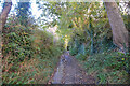
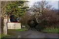
Barnstaple : Derby Road
A track heads up the hill.
Image: © Lewis Clarke
Taken: 29 Oct 2021
0.11 miles
8
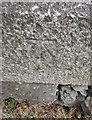
Ordnance Survey Cut Mark
This OS cut mark can be found on the SE corner post of the cemetery. It marks a point 15.554m above mean sea level.
Image: © Adrian Dust
Taken: 8 Jul 2016
0.16 miles
9
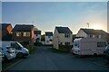
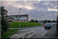
Barnstaple : Longmeadow Drive
A car park area for residents.
Image: © Lewis Clarke
Taken: 7 Mar 2022
0.17 miles
10
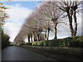
Pollarded trees line the cemetery, on Goodleigh Road
Image: © Roger Cornfoot
Taken: 22 Nov 2014
0.17 miles