
IMAGES TAKEN NEAR TO
Lethaby Road, BARNSTAPLE, EX32 7HQ
Introduction
This page details the photographs taken nearby to Lethaby Road, EX32 7HQ by members of the Geograph project.
The Geograph project started in 2005 with the aim of publishing, organising and preserving representative images for every square kilometre of Great Britain, Ireland and the Isle of Man.

There are currently over 7.5m images from over14,400 individuals and you can help contribute to the project by visiting https://www.geograph.org.uk
Image Map
Images are licensed for reuse under creativecommons.org/licenses/by-sa/2.0
Notes
- Clicking on the map will re-center to the selected point.
- The higher the marker number, the further away the image location is from the centre of the postcode.
Image Listing (44 Images Found)
Images are licensed for reuse under creativecommons.org/licenses/by-sa/2.0
Image
Details
Distance
1
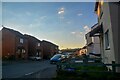
Barnstaple : Heppenstall Road
Looking along the road.
Image: © Lewis Clarke
Taken: 7 Mar 2022
0.03 miles
2
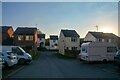
Barnstaple : Longmeadow Drive
A car park area for residents.
Image: © Lewis Clarke
Taken: 7 Mar 2022
0.05 miles
3

Barnstaple : Heppenstall Road
A car park off the road for residents.
Image: © Lewis Clarke
Taken: 7 Mar 2022
0.12 miles
4
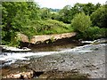
Lynton & Barnstaple Railway Bridge 8
All that remains of the east abutment of Bridge 8 "Raleigh Weir Bridge" which carried the Lynton & Barnstaple Railway across the River Yeo at Raleigh Weir for the last time in 1935. The bridge itself is long gone, and much of the trackbed is now overgrown. The track ran from the west bank of the river, just out of shot on the left, and into the trees far right
The Lynton & Barnstaple Railway was a 19 mile long narrow gauge railway, which ran across the stunning Exmoor landscape, from 1898, until its closure in 1935. In 2004, after many years of hard work and negotiation, a small section was re-opened. One of the world’s most famous little railways, you can read more of the exciting plans for the coming years at www.lynton-rail.co.uk
Image: © Barrie Cann
Taken: 28 May 2017
0.13 miles
5
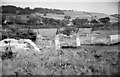
Derelict railway bridge over the River Yeo
The narrow gauge Lynton & Barnstaple Rly closed in September 1935 & the iron girders of the bridge were no doubt soon removed. To the immediate right is Rayleigh Weir which marks the highest tidal point on the river.
At some time in the future the re-invigorated L&BR really will reach Barnstaple again & this bridge will be rebuilt to carry trains. However, at the time of the photograph that would have seemed an outlandish idea!
Image: © Martin Tester
Taken: 24 Aug 1966
0.13 miles
6
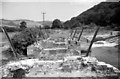
Derelict railway bridge over the River Yeo at Raleigh Weir
A view straight over the bridge with the trackbed stretching into the distance. Compare this with Image which shows an oblique view.
The narrow gauge Lynton & Barnstaple Rly closed in September 1935 & the iron girders of the bridge were no doubt soon removed. To the immediate right is Rayleigh Weir which marks the highest tidal point on the river.
At some time in the future the re-invigorated L&BR really will reach Barnstaple again & this bridge will be rebuilt to carry trains. However, at the time of the photograph that would have seemed an outlandish idea!
Image: © Martin Tester
Taken: 24 Aug 1966
0.13 miles
7
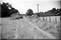
Looking west along L&BR trackbed on the outskirts of Barnstaple
Looking along the derelict Lynton & Barnstaple Rly trackbed towards Barnstaple. In the distance can be seen the diagonal iron handrail supports of the bridge over the River Yeo at Raleigh Weir. For a view of the bridge looking towards my current position see: Image
For a view from the same position looking towards Lynton see:Image
Image: © Martin Tester
Taken: 24 Aug 1966
0.13 miles
8
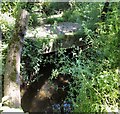
Lynton and Barnstaple Railway Bridge number 9
Though still largely intact, having last been used to carry trains across the narrow stream beneath in 1935. this short concrete ‘bridge’ or culvert is now virtually overgrown. Still accessible to walkers and dog-owners, the view for photographers is somewhat less than perfect, due to the undergrowth
There is a clearer view of this bridge, taken a few years ago, on the Lynton and Barnstaple Railway web-site
http://www.lynton-rail.co.uk/files/resize/embedded/images/zx60-220x165.jpg
The Lynton & Barnstaple Railway was a 19 mile long narrow gauge railway, which ran across the stunning Exmoor landscape, from 1898, until its closure in 1935. In 2004, after many years of hard work and negotiation, a small section was re-opened. One of the world’s most famous little railways, you can read more of the exciting plans for the coming years at www.lynton-rail.co.uk
Image: © Barrie Cann
Taken: 17 Jun 2017
0.14 miles
9

Lynton and Barnstaple Railway disused trackbed
Long-disused trackbed of the Lynton and Barnstaple Railway, which last carried trains along the banks of the River Yeo into Barnstaple in 1935
The Lynton & Barnstaple Railway was a 19 mile long narrow gauge railway, which ran across the stunning Exmoor landscape, from 1898, until its closure in 1935. In 2004, after many years of hard work and negotiation, a small section was re-opened. One of the world’s most famous little railways, you can read more of the exciting plans for the coming years at www.lynton-rail.co.uk
Image: © Barrie Cann
Taken: 28 May 2017
0.15 miles
10
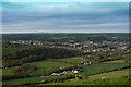
A view across Barnstaple from Roborough Road
The grid reference given for this image is its centre which is at Sowden Lane.
The mast at Huntshaw is barely visible just left of centre on the horizon.
Image: © Roger A Smith
Taken: 13 Apr 2020
0.15 miles