IMAGES TAKEN NEAR TO
Crookmans Close, BARNSTAPLE, EX32 7FY
Introduction
This page details the photographs taken nearby to Crookmans Close, EX32 7FY by members of the Geograph project.
The Geograph project started in 2005 with the aim of publishing, organising and preserving representative images for every square kilometre of Great Britain, Ireland and the Isle of Man.

There are currently over 7.5m images from over14,400 individuals and you can help contribute to the project by visiting https://www.geograph.org.uk
Image Map
Images are licensed for reuse under creativecommons.org/licenses/by-sa/2.0
Notes
- Clicking on the map will re-center to the selected point.
- The higher the marker number, the further away the image location is from the centre of the postcode.
Image Listing (24 Images Found)
Images are licensed for reuse under creativecommons.org/licenses/by-sa/2.0
Image
Details
Distance
1
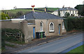
Old Toll House by Crookman's Corner, Barnstaple
Toll House in the parish of Barnstaple (North Devon District), Toll Gate Cottage, Crookman's Corner, Goodleigh Road, EX32 7JP.
Grade II listed.
List Entry Number: 1385132 https://historicengland.org.uk/listing/the-list/list-entry/1385132
Surveyed
Milestone Society National ID: DV.BAR
Image: © Alan Rosevear
Taken: 24 Nov 2008
0.05 miles
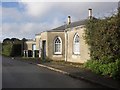
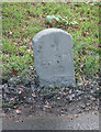
3
Milestone - Barnstaple 1
South side of road.
Image: © Adrian Dust
Taken: 23 Apr 2015
0.05 miles
4
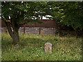
1 mile to Barum on the Goodleigh Road near Crookman's Corner
Barum is an alternative name for Barnstaple.
Image: © Roger A Smith
Taken: 25 Jul 2013
0.06 miles
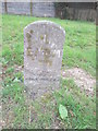
5
Old Milestone by Goodleigh Road, Barnstaple
Carved stone post by the UC road, in parish of BARNSTAPLE (NORTH DEVON District), Goodleigh Road, 50m West of Crookman's Corner former tollhouse, on grass verge, tight against the road, on South side of road. Barum tombstone, erected by the Barnstaple turnpike trust in the 19th century.
Inscription reads:-
1
BARUM
Grade II Listed. List Entry Number:1385131
https://historicengland.org.uk/listing/the-list/list-entry/1385131
Milestone Society National ID: DV_BSIFc01.
Image: © Alan Rosevear
Taken: 24 Nov 2008
0.06 miles