IMAGES TAKEN NEAR TO
Sunflower Road, BARNSTAPLE, EX32 7DU
Introduction
This page details the photographs taken nearby to Sunflower Road, EX32 7DU by members of the Geograph project.
The Geograph project started in 2005 with the aim of publishing, organising and preserving representative images for every square kilometre of Great Britain, Ireland and the Isle of Man.

There are currently over 7.5m images from over14,400 individuals and you can help contribute to the project by visiting https://www.geograph.org.uk
Image Map
Images are licensed for reuse under creativecommons.org/licenses/by-sa/2.0
Notes
- Clicking on the map will re-center to the selected point.
- The higher the marker number, the further away the image location is from the centre of the postcode.
Image Listing (214 Images Found)
Images are licensed for reuse under creativecommons.org/licenses/by-sa/2.0
Image
Details
Distance
1
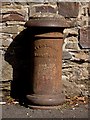
The remains of a sewage vent pipe bearing the name T S Colbourne, Barnstaple
Image: © Roger A Smith
Taken: 15 Sep 2015
0.02 miles
2
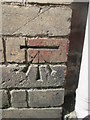
Ordnance Survey Cut Mark
This OS cut mark can be found on the NE face of the Church Hall on Richmond Street. It marks a point 14.926m above mean sea level.
Image: © Adrian Dust
Taken: 23 Apr 2015
0.03 miles
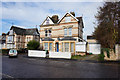
4
Miller Crescent
Off Bicton Street, Barnstaple.
Image: © Ian S
Taken: 7 Nov 2015
0.05 miles


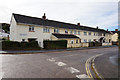
9
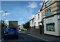
Shop, houses and traffic on Bear Street, looking west
Image: © Rob Purvis
Taken: 19 Sep 2017
0.07 miles
