IMAGES TAKEN NEAR TO
Coronation Street, BARNSTAPLE, EX32 7BA
Introduction
This page details the photographs taken nearby to Coronation Street, EX32 7BA by members of the Geograph project.
The Geograph project started in 2005 with the aim of publishing, organising and preserving representative images for every square kilometre of Great Britain, Ireland and the Isle of Man.

There are currently over 7.5m images from over14,400 individuals and you can help contribute to the project by visiting https://www.geograph.org.uk
Image Map
Images are licensed for reuse under creativecommons.org/licenses/by-sa/2.0
Notes
- Clicking on the map will re-center to the selected point.
- The higher the marker number, the further away the image location is from the centre of the postcode.
Image Listing (745 Images Found)
Images are licensed for reuse under creativecommons.org/licenses/by-sa/2.0
Image
Details
Distance
1

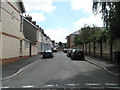
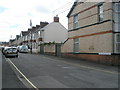
A less famous Coronation Street
This one is in Barnstaple.
Image: © Basher Eyre
Taken: 8 Aug 2008
0.01 miles
2
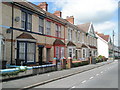
Looking from Coronation Street towards King Edward Street
Image: © Basher Eyre
Taken: 8 Aug 2008
0.02 miles
4
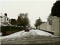
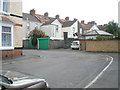
Coronation Street leading away from Boutport Street
Image: © Roger A Smith
Taken: 6 Jan 2010
0.03 miles
5
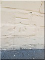
Ordnance Survey Cut Mark
This OS cut mark can be found on the wall of No23 Coronation Street. It marks a point 8.248m above mean sea level.
Image: © Adrian Dust
Taken: 23 Apr 2015
0.03 miles
8

Junction of Coronation and King Edward Streets
Image: © Basher Eyre
Taken: 8 Aug 2008
0.04 miles
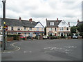
10
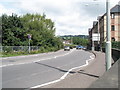
Looking eastwards on the A361 from Boutport Street Roundabout
Image: © Basher Eyre
Taken: 8 Aug 2008
0.04 miles