IMAGES TAKEN NEAR TO
Bramble Path, BARNSTAPLE, EX32 0UG
Introduction
This page details the photographs taken nearby to Bramble Path, EX32 0UG by members of the Geograph project.
The Geograph project started in 2005 with the aim of publishing, organising and preserving representative images for every square kilometre of Great Britain, Ireland and the Isle of Man.

There are currently over 7.5m images from over14,400 individuals and you can help contribute to the project by visiting https://www.geograph.org.uk
Image Map
Images are licensed for reuse under creativecommons.org/licenses/by-sa/2.0
Notes
- Clicking on the map will re-center to the selected point.
- The higher the marker number, the further away the image location is from the centre of the postcode.
Image Listing (29 Images Found)
Images are licensed for reuse under creativecommons.org/licenses/by-sa/2.0
Image
Details
Distance

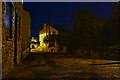
2
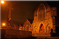
Landkey : Blakes Hill Road
The war memorial and Nonconformist Chapel can be seen here.
Image: © Lewis Clarke
Taken: 22 Dec 2016
0.06 miles
3

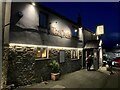
Landkey : War Memorial
The war memorial on Blakes Hill Road.
Image: © Lewis Clarke
Taken: 14 Mar 2020
0.07 miles
4
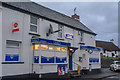
Landkey : Landkey Stores
A shop on Blakes Hill Road.
Image: © Lewis Clarke
Taken: 14 Mar 2020
0.07 miles
5
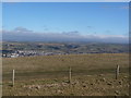
A view of Landkey from the monument on Codden Beacon
See also: Image
Image: © Roger A Smith
Taken: 10 Mar 2010
0.07 miles
7
Landkey : Manor Road
Looking along Manor Road in Landkey.
Image: © Lewis Clarke
Taken: 22 Dec 2016
0.07 miles

9
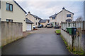
Landkey : Challacombe Close
Looking into Challacombe Close.
Image: © Lewis Clarke
Taken: 14 Mar 2020
0.09 miles
10
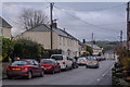
Landkey : Blakes Hill Road
Looking along Blakes Hill Road.
Image: © Lewis Clarke
Taken: 14 Mar 2020
0.11 miles