IMAGES TAKEN NEAR TO
East Buckland, BARNSTAPLE, EX32 0TG
Introduction
This page details the photographs taken nearby to EX32 0TG by members of the Geograph project.
The Geograph project started in 2005 with the aim of publishing, organising and preserving representative images for every square kilometre of Great Britain, Ireland and the Isle of Man.

There are currently over 7.5m images from over14,400 individuals and you can help contribute to the project by visiting https://www.geograph.org.uk
Image Map (Loading...)


Getting Data...Please wait
Leaflet Map data © OpenStreetMap
Images are licensed for reuse under creativecommons.org/licenses/by-sa/2.0
Notes
- Clicking on the map will re-center to the selected point.
- The higher the marker number, the further away the image location is from the centre of the postcode.
Image Listing (18 Images Found)
Images are licensed for reuse under creativecommons.org/licenses/by-sa/2.0
Image
Details
Distance
1
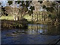
River Bray
The river has just completed an S-bend as it approaches the camera in the southeastern corner of the square. Seen from beneath an Acer - probably a sycamore.
Image: © Derek Harper
Taken: 23 Nov 2007
0.16 miles
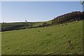
2

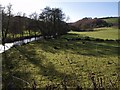
Bray valley
A view across fields on the western slopes, down to the valley floor, taken from the point where the farm drive to Brayley Barton leaves Brayley Hill. The far side of the valley, with Embercombe Wood on the steep slopes is in square SS6929.
Image: © Derek Harper
Taken: 23 Nov 2007
0.16 miles
3
Punch Bowl Wood from Brayley Hill
The round wood occupies a combe on the western slopes of the Bray valley.
Image: © Derek Harper
Taken: 23 Nov 2007
0.18 miles
4
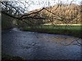
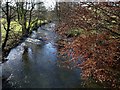
River Bray
The river, one of the Taw's major tributaries, runs across a narrow valley floor between wooded slopes. On the far side is Park Wood.
Image: © Derek Harper
Taken: 23 Nov 2007
0.19 miles
5
East and West Buckland: Bray valley
View north near Brayley Bridge
Image: © Martin Bodman
Taken: 17 Mar 2003
0.20 miles
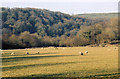
6
Bray valley
The western side of the valley, taken a few yards west of Image, and looking downstream to where the valley narrows in SS6829, with Park Wood on the slopes.
Image: © Derek Harper
Taken: 23 Nov 2007
0.21 miles
7
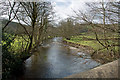
River Bray from Brayley Bridge
Looking downstream from Image, past the beech shown in that photo. The river is close to the western edge of its floodplain.
Image: © Derek Harper
Taken: 23 Nov 2007
0.21 miles
9
Looking down the river Bray from Brayley Bridge
Image: © Roger A Smith
Taken: 18 Mar 2014
0.23 miles
10
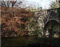
Brayley Bridge
A solid-looking stone bridge across the River Bray, with autumnal beech leaves. The river is flowing to the left.
Image: © Derek Harper
Taken: 23 Nov 2007
0.23 miles