IMAGES TAKEN NEAR TO
Filleigh, BARNSTAPLE, EX32 0TF
Introduction
This page details the photographs taken nearby to EX32 0TF by members of the Geograph project.
The Geograph project started in 2005 with the aim of publishing, organising and preserving representative images for every square kilometre of Great Britain, Ireland and the Isle of Man.

There are currently over 7.5m images from over14,400 individuals and you can help contribute to the project by visiting https://www.geograph.org.uk
Image Map
Images are licensed for reuse under creativecommons.org/licenses/by-sa/2.0
Notes
- Clicking on the map will re-center to the selected point.
- The higher the marker number, the further away the image location is from the centre of the postcode.
Image Listing (15 Images Found)
Images are licensed for reuse under creativecommons.org/licenses/by-sa/2.0
Image
Details
Distance
1
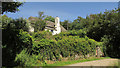
Former farmhouse, West Blakewell
The thatched cottage is described at https://historicengland.org.uk/listing/the-list/list-entry/1107555 . The lane is from East Buckland.
Image: © Derek Harper
Taken: 22 Jun 2019
0.00 miles
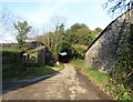
3
Barn, East Blakewell
At Blakewell Cross. West and East Blakewell aren't far apart - either side of this narrow lane, in fact. Two LDPs pass the junction - the Tarka Trail and Macmillan Way West.
Image: © Derek Harper
Taken: 22 Jun 2019
0.02 miles
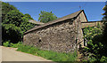
4
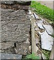
Ordnance Survey Cut Mark
This OS cut mark can be found on the SE angle of a farm building at Blakewell Farm. It marks a point 134.057m above mean sea level.
Image: © Adrian Dust
Taken: 7 Jul 2016
0.03 miles
5
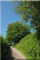
Blakewell Hill
Climbing steeply from Blakewell Cross - indeed, part of this lane has double arrows on the map.
Image: © Derek Harper
Taken: 22 Jun 2019
0.07 miles
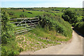
7
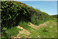
Hedge by Blakewell Hill
Looking left from the gate shown in Image
Image: © Derek Harper
Taken: 22 Jun 2019
0.11 miles
8
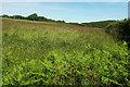
Grass field by Blakewell Hill
On the right is the hedge seen from the other side in Image In the distance, across the Bray valley, is Lowdy Cleave Wood.
Image: © Derek Harper
Taken: 22 Jun 2019
0.11 miles
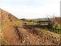
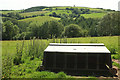
9
Blakewell Hill
Looking down the stretch of land that Image] looks up. The farm buildings (centre) across the Bray valley are at Rapscott.
Image: © Derek Harper
Taken: 22 Jun 2019
0.11 miles
10
From Blakewell Hill
A view on the other side of the lane from Image Across the field the ground drops away into Charles Bottom. Left of centre, on the far hillside is Punch Bowl Wood.
Image: © Derek Harper
Taken: 22 Jun 2019
0.12 miles