IMAGES TAKEN NEAR TO
East Buckland, BARNSTAPLE, EX32 0TD
Introduction
This page details the photographs taken nearby to EX32 0TD by members of the Geograph project.
The Geograph project started in 2005 with the aim of publishing, organising and preserving representative images for every square kilometre of Great Britain, Ireland and the Isle of Man.

There are currently over 7.5m images from over14,400 individuals and you can help contribute to the project by visiting https://www.geograph.org.uk
Image Map (Loading...)


Getting Data...Please wait
Leaflet Map data © OpenStreetMap
Images are licensed for reuse under creativecommons.org/licenses/by-sa/2.0
Notes
- Clicking on the map will re-center to the selected point.
- The higher the marker number, the further away the image location is from the centre of the postcode.
Image Listing (30 Images Found)
Images are licensed for reuse under creativecommons.org/licenses/by-sa/2.0
Image
Details
Distance
1
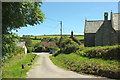
Tarka Trail in East Buckland
Following, together with the Macmillan Way West, Mill Lane past St Michael's church (right). The thatched building right of centre is shown in Image
Image: © Derek Harper
Taken: 22 Jun 2019
0.02 miles
2
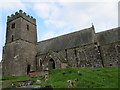
The church of St Michael at East Buckland
Image: © Peter Wood
Taken: 13 Oct 2013
0.03 miles
3
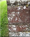
Ordnance Survey Cut Mark
This OS cut mark can be found on the north face of St Michael's Church. It marks a point 177.887m above mean sea level.
Image: © Adrian Dust
Taken: 7 Jul 2016
0.03 miles
5
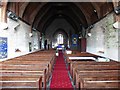
Interior, St Michael's Church, East Buckland
Image: © Roger Cornfoot
Taken: 26 Nov 2018
0.04 miles
7

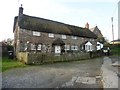
Church Cottages, East Buckland
Church Cottages were "probably originally a single tenement. C16, with possibly earlier origins, extended in C17" https://historicengland.org.uk/listing/the-list/list-entry/1310218 . "The close proximity of the cottages to the church suggests they may have originally served as a church-house." They also appear in Image
Image: © Derek Harper
Taken: 22 Jun 2019
0.04 miles
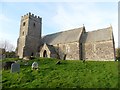
8

St Michael's Church, East Buckland
From the southern edge of the churchyard. https://historicengland.org.uk/listing/the-list/list-entry/1325327
Image: © Derek Harper
Taken: 22 Jun 2019
0.04 miles
9
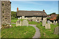
Churchyard, East Buckland
Looking round a corner of St Michael’s Church and across the churchyard to Church Cottages, "probably originally a single tenement. C16, with possibly earlier origins, extended in C17" https://historicengland.org.uk/listing/the-list/list-entry/1310218 . "The close proximity of the cottages to the church suggests they may have originally served as a church-house."
Image: © Derek Harper
Taken: 22 Jun 2019
0.04 miles
10
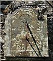
Sundial, East Buckland
A Thomas Berry slate sundial, of 1819, on the porch gable at St Michael's Church. http://sundialsoc.org.uk/dials/st-michaels-church-over-porch0368/
Image: © Derek Harper
Taken: 22 Jun 2019
0.04 miles