IMAGES TAKEN NEAR TO
East Buckland, BARNSTAPLE, EX32 0TB
Introduction
This page details the photographs taken nearby to EX32 0TB by members of the Geograph project.
The Geograph project started in 2005 with the aim of publishing, organising and preserving representative images for every square kilometre of Great Britain, Ireland and the Isle of Man.

There are currently over 7.5m images from over14,400 individuals and you can help contribute to the project by visiting https://www.geograph.org.uk
Image Map
Images are licensed for reuse under creativecommons.org/licenses/by-sa/2.0
Notes
- Clicking on the map will re-center to the selected point.
- The higher the marker number, the further away the image location is from the centre of the postcode.
Image Listing (25 Images Found)
Images are licensed for reuse under creativecommons.org/licenses/by-sa/2.0
Image
Details
Distance
1
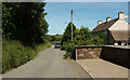
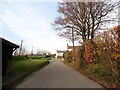
Mill Lane, East Buckland
The lane leads from East Buckland Cross to the village's centre and is followed by both the Tarka Trail and the Macmillan Way West. On the right are Glebeland Villas.
Image: © Derek Harper
Taken: 22 Jun 2019
0.01 miles
3
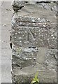
Ordnance Survey Cut Mark
This OS cut mark can be found on the old barn at the crossroads. It marks a point 189.866m above mean sea level.
Image: © Adrian Dust
Taken: 7 Jul 2016
0.03 miles
4
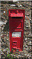
Postbox, East Buckland Cross
Victorian postbox number EX32 12 is visible in Image
Image: © Derek Harper
Taken: 22 Jun 2019
0.04 miles
6
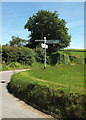
East Buckland Cross
The signpost can also be made out in Image The cottage shown in Image] is off to the left. The two LDPs, the Tarka Trail and the Macmillan Way West, pass this way, following the lanes to right and left signposted West and East Buckland.
Image: © Derek Harper
Taken: 22 Jun 2019
0.05 miles
7
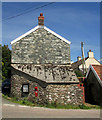
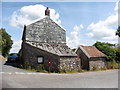
Cottage, East Buckland Cross
The Tarka Trail and the Macmillan Way West both cross this crossroads, keeping to the left of the cottage. The Victorian postbox is number EX32 12.
Image: © Derek Harper
Taken: 22 Jun 2019
0.07 miles
8
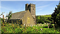
St Michael's Church, East Buckland
The church is described at https://historicengland.org.uk/listing/the-list/list-entry/1325327 and is also shown at https://www.geograph.org.uk/search.php?i=112848116 . This view is from the lane on the north side, which carries both the Tarka Trail and the Macmillan Way West.
Image: © Derek Harper
Taken: 22 Jun 2019
0.12 miles
9
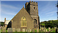
St Michael's Church, East Buckland
"Probably C15 tower, nave pulled down and rebuilt with a chancel in the position of a north aisle in 1860" - R D Gould was the architect at the time. See also https://www.geograph.org.uk/search.php?i=112848116 . Some of the headstones, particularly those that are nowy arched, are among those described at https://historicengland.org.uk/listing/the-list/list-entry/1161217 .
Image: © Derek Harper
Taken: 22 Jun 2019
0.12 miles
10
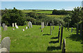
Churchyard, East Buckland
Of St Michael's church; the tower is directly behind the camera.
Image: © Derek Harper
Taken: 22 Jun 2019
0.13 miles