IMAGES TAKEN NEAR TO
Pathfield Close, BARNSTAPLE, EX32 0SY
Introduction
This page details the photographs taken nearby to Pathfield Close, EX32 0SY by members of the Geograph project.
The Geograph project started in 2005 with the aim of publishing, organising and preserving representative images for every square kilometre of Great Britain, Ireland and the Isle of Man.

There are currently over 7.5m images from over14,400 individuals and you can help contribute to the project by visiting https://www.geograph.org.uk
Image Map (Loading...)


Getting Data...Please wait
Leaflet Map data © OpenStreetMap
Images are licensed for reuse under creativecommons.org/licenses/by-sa/2.0
Notes
- Clicking on the map will re-center to the selected point.
- The higher the marker number, the further away the image location is from the centre of the postcode.
Image Listing (38 Images Found)
Images are licensed for reuse under creativecommons.org/licenses/by-sa/2.0
Image
Details
Distance
4
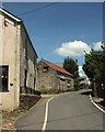
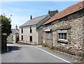
Village street, West Buckland
With an interesting old outbuilding a few metres ahead.
Image: © Derek Harper
Taken: 22 Jun 2019
0.07 miles
5
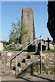
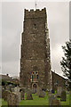
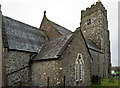
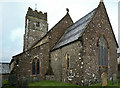
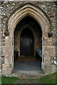
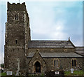
West Buckland: St Peter?s church
Looking east to the west tower, the only part of the church to escape the 19th century rebuilding. Note the raised churchyard, just possibly an indication of a pre-Christian site
Image: © Martin Bodman
Taken: 18 Apr 2007
0.08 miles