IMAGES TAKEN NEAR TO
West Buckland, BARNSTAPLE, EX32 0SW
Introduction
This page details the photographs taken nearby to EX32 0SW by members of the Geograph project.
The Geograph project started in 2005 with the aim of publishing, organising and preserving representative images for every square kilometre of Great Britain, Ireland and the Isle of Man.

There are currently over 7.5m images from over14,400 individuals and you can help contribute to the project by visiting https://www.geograph.org.uk
Image Map (Loading...)


Getting Data...Please wait
Leaflet Map data © OpenStreetMap
Images are licensed for reuse under creativecommons.org/licenses/by-sa/2.0
Notes
- Clicking on the map will re-center to the selected point.
- The higher the marker number, the further away the image location is from the centre of the postcode.
Image Listing (13 Images Found)
Images are licensed for reuse under creativecommons.org/licenses/by-sa/2.0
Image
Details
Distance
1
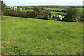
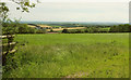
Field near Elwell
Elwell House is right of centre. Away to the left is West Buckland School. Taken from a bend in the lane east of Stoodleigh Cross.
Image: © Derek Harper
Taken: 22 Jun 2019
0.03 miles
2
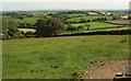
Field near Elwell
Looking right from Image The village and church away to the right is West Buckland.
Image: © Derek Harper
Taken: 22 Jun 2019
0.10 miles
3
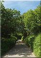
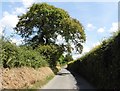
Lane to Stoodleigh Cross
Image: © Derek Harper
Taken: 22 Jun 2019
0.11 miles
4
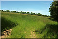
Field north of Elwell
From a gateway at the same bend where Image] was taken.
Image: © Derek Harper
Taken: 22 Jun 2019
0.14 miles
5
Lane to Stoodleigh Cross
Looking in the opposite direction to Image
Image: © Derek Harper
Taken: 22 Jun 2019
0.14 miles
6
Towards West Buckland
Image: © Derek Harper
Taken: 22 Jun 2019
0.15 miles
7
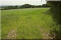
Field near Elwell
From the lane between Stoodleigh Cross and Upcott Cross.
Image: © Derek Harper
Taken: 22 Jun 2019
0.19 miles
9
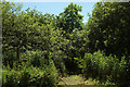
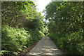
Tarka Trail near West Buckland
Looking right from Image, with East and West Buckland footpath 1 carrying both the Tarka Trail and the Macmillan Way West away from the lane towards West Buckland. A conglomeration of trees around the spot perhaps justifies the classification of woodland.
Image: © Derek Harper
Taken: 22 Jun 2019
0.20 miles
10
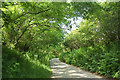
Lane to Upcott Cross
Looking right from Image
Image: © Derek Harper
Taken: 22 Jun 2019
0.20 miles