IMAGES TAKEN NEAR TO
Yeoland Lane, BARNSTAPLE, EX32 0QU
Introduction
This page details the photographs taken nearby to Yeoland Lane, EX32 0QU by members of the Geograph project.
The Geograph project started in 2005 with the aim of publishing, organising and preserving representative images for every square kilometre of Great Britain, Ireland and the Isle of Man.

There are currently over 7.5m images from over14,400 individuals and you can help contribute to the project by visiting https://www.geograph.org.uk
Image Map (Loading...)


Getting Data...Please wait
Leaflet Map data © OpenStreetMap
Images are licensed for reuse under creativecommons.org/licenses/by-sa/2.0
Notes
- Clicking on the map will re-center to the selected point.
- The higher the marker number, the further away the image location is from the centre of the postcode.
Image Listing (6 Images Found)
Images are licensed for reuse under creativecommons.org/licenses/by-sa/2.0
Image
Details
Distance
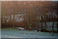
1
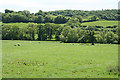
Swimbridge: near Yeoland House
Looking south towards the North Devon Link Road which is hidden beyond the trees that stand at the foot of the field
Image: © Martin Bodman
Taken: 22 May 2007
0.08 miles
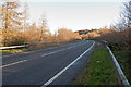
2
Venn Stream passing through a field near the A361
Image: © Roger A Smith
Taken: 10 Dec 2012
0.15 miles
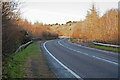
4
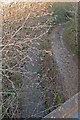
Looking up Venn Stream from a Bridge on the A361
Image: © Roger A Smith
Taken: 10 Dec 2012
0.24 miles